
Ottawa Reels from Direct Tornado Hit (Image Credits: Upload.wikimedia.org)
Kansas – A tornado tore through Ottawa late Monday evening, damaging homes and businesses while knocking out power across the community. Forecasters tracked additional twisters across Kansas, Minnesota, Iowa, and Wisconsin as storms intensified, prompting a cascade of severe weather warnings. Nearly 70 million people from Texas to New England now brace for days of potential hazards including large hail, damaging winds, and more tornadoes.[1][2]
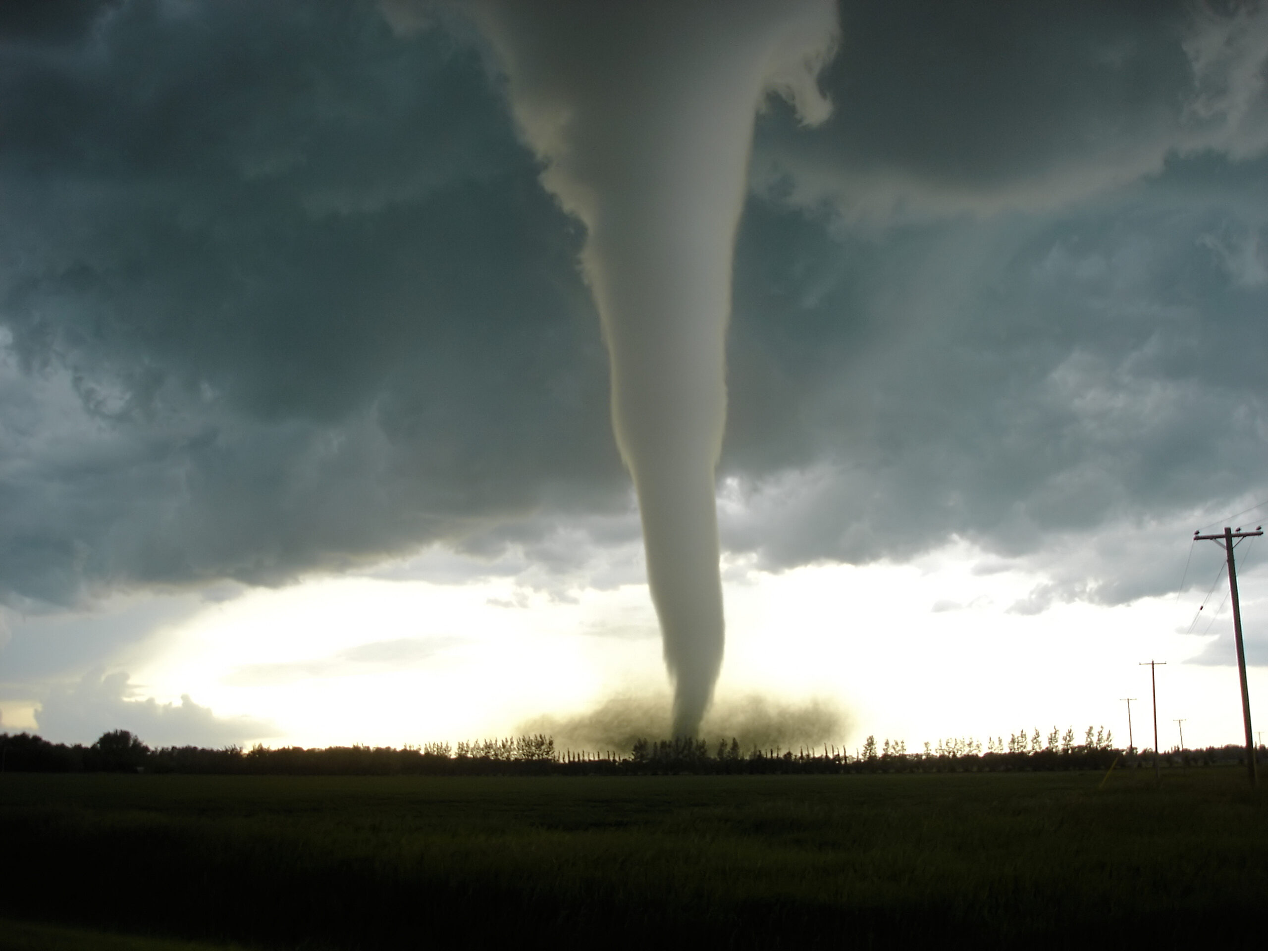
Ottawa Reels from Direct Tornado Hit
The tornado descended on Ottawa shortly before 8 p.m., carving a path through populated areas and snapping power poles. Local authorities reported structural damage to several buildings, with full assessments delayed until daylight due to outages. Ottawa Police Chief Adam Weingarten noted that emergency teams worked through the night to secure the area.[1][3]
In nearby Hillsdale, another tornado injured two people and destroyed homes, businesses, and recreational vehicles. Storm chasers captured video of the multi-vortex funnels, highlighting the storms’ potency. Preliminary surveys confirmed impacts in Franklin County, including touchdown at 15th and Eisenhower streets.[4]
Wave of Tornado Reports Spans Midwest
At least 14 preliminary tornadoes dotted the landscape on April 13, affecting rural and semi-urban zones alike. Kansas saw the heaviest concentration, with sightings near Quenemo, Pomona, Blue Mound, Spring Hill, and Pleasanton. Minnesota logged three events west of Amboy, near Truman, and by Matawan, accompanied by tennis-ball-sized hail.[2]
Iowa confirmed twisters north of Emmetsburg, near Graettinger, and by Webb in the northwest. Wisconsin reported one near Hannibal in Taylor County. No fatalities occurred, though agricultural outbuildings and utility lines bore the brunt of the damage.[2]
- Near Quenemo, Kansas: Sheet metal shed destroyed.
- Ottawa, Kansas: Homes, businesses, power infrastructure hit.
- Amboy, Minnesota: Farm outbuilding damaged.
- Emmetsburg, Iowa: Visual confirmations in Palo Alto County.
- Hannibal, Wisconsin: Intermittent touchdown in Taylor County.
SPC Elevates Risks for Tuesday Onslaught
The Storm Prediction Center outlined an Enhanced risk for severe thunderstorms across eastern Iowa, northern Illinois, and southern Wisconsin on Tuesday. Very large hail up to 2-3 inches, damaging wind gusts, and a few tornadoes—some potentially strong—loom as primary threats. Bulk shear of 45-55 knots and high instability fuel supercell development along stalled boundaries.[5]
Slight risks extend to the central and southern Plains, including eastern Kansas, Oklahoma, and Texas, with large hail exceeding 2 inches possible. Chicago, Des Moines, Milwaukee, Kansas City, and Detroit sit in vulnerable spots. Over 130 million from Texas to New York face the multi-day pattern, with storms redeveloping through Wednesday.[4][5]
| Risk Level | Areas | Key Threats |
|---|---|---|
| Enhanced | Eastern Iowa, N. Illinois, S. Wisconsin | 2-3″ hail, strong tornadoes, winds |
| Slight | E. Kansas, OK, TX; Northeast | Large hail, tornadoes, gusts |
Flooding and Flash Concerns Compound Dangers
Heavy rain spurred flash flood warnings in Green Bay, Wisconsin, persisting into late Monday. In Michigan, Governor Gretchen Whitmer’s state of emergency at Cheboygan Dam highlighted rising waters from snowmelt and storms near Lake Huron. Evacuation preparations continued as more precipitation arrived overnight.[1]
Meteorologist Jared Guyer of the Storm Prediction Center attributed the pattern to classic April dynamics: warm Gulf moisture clashing with weather systems. Threats pause briefly Thursday before resuming Friday, urging vigilance across the warm sector.[1]
Key Takeaways
- April 13 tornadoes caused property damage but no deaths; surveys ongoing.
- Tuesday’s Enhanced risk targets Midwest supercells with strong tornado potential.
- Multi-day storms affect 70-130 million; monitor local alerts closely.
As cleanup begins in Kansas and neighbors prepare, this outbreak underscores spring’s volatile weather. Residents should secure plans and stay informed. What do you think about these escalating storm risks? Tell us in the comments.
- Urban Coyotes Show Remarkable Adaptability, Learning to Thrive in City Environments - July 22, 2026
- Beavers Are Nature’s Engineers, Creating Vital Habitats for Other Wildlife Species - July 21, 2026
- The Recovery of the California Condor Offers Hope for Other Critically Endangered Birds - July 21, 2026