Morning Showers and Fog Challenge Drivers (Image Credits: Fox2now.com)
St. Louis – Fresh waves of precipitation arrived early Tuesday, launching a stretch of unsettled weather expected to deliver several inches of rain across the region through the weekend.[1]
Morning Showers and Fog Challenge Drivers
Rain accompanied by thunder rumbled through the area before dawn on March 3. Dense fog and low-hanging clouds reduced visibility further, complicating the morning commute. These conditions also obscured views of the lunar eclipse for early risers. Scattered showers lingered into mid-morning before easing somewhat.[1]
Cloudy skies dominated Tuesday, with highs reaching the 50s. Lighter drizzle appeared in spots during the afternoon. Another surge of rain built in the evening, primarily north of the city, such as from Bowling Green, Missouri, to Carlinville, Illinois. Heavier elements from that system pushed southward overnight.[1]
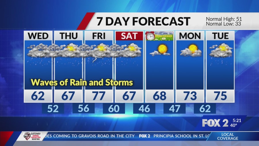
Multiple Rounds Forecast Through Saturday
Forecasters predict frequent wet episodes ahead. Showers and thunderstorms will recur from Wednesday onward. A stalled frontal boundary keeps the pattern locked in place. Rainfall rates could intensify during some bursts.[2][3]
Here is a snapshot of expected conditions:
- Tuesday: High near 51°F, 40% rain chance, transitioning to evening showers.[2]
- Wednesday: High around 66°F, 70% chance of showers and thunderstorms.
- Thursday: Milder at 70°F, 60% precipitation probability.
- Friday: Warm high of 81°F, but 30% showers before noon.
- Saturday: Cooling to 68°F high, 60% storms in the morning.[2]
Warmer Air Fuels Spring Preview
Temperatures trend upward after Tuesday’s cooler start. Midweek highs approach 70°F or more. Lows hover in the 50s and 60s during peak activity. This shift brings a taste of spring despite the persistent moisture.[2]
The warming supports all rain, no wintry mix concerns. Winds remain light, generally under 10 mph from the east to southeast. Partly cloudy breaks may appear between systems later in the week.
Rainfall Eases Regional Drought Pressures
Several inches of accumulation stand to benefit Missouri and Illinois. Recent dry spells had intensified drought conditions in parts of both states. Central Illinois faced extreme shortages entering March. This week’s totals offer meaningful replenishment for soils and streams.[1][4]
Missouri’s weather dashboard tracks ongoing drought metrics, including days without significant rain. The incoming precipitation aligns with severe weather preparedness efforts during March 2-6.[5]
Key Takeaways
- Expect 80%+ chances of showers most days through Saturday.
- Total rainfall could exceed several inches, aiding drought recovery.
- Warmer temperatures mid-week, but watch for heavy downpours and thunder.
Residents should secure outdoor items and monitor local updates. Frequent wet roads demand cautious driving. The pattern delivers much-needed moisture while testing daily routines. How will you navigate this soggy stretch? Share your plans in the comments.
- Urban Coyotes Show Remarkable Adaptability, Learning to Thrive in City Environments - July 22, 2026
- Beavers Are Nature’s Engineers, Creating Vital Habitats for Other Wildlife Species - July 21, 2026
- The Recovery of the California Condor Offers Hope for Other Critically Endangered Birds - July 21, 2026