
Mild Conditions Persist Through Midweek (Image Credits: Fox2now.com)
St. Louis residents are experiencing a gentle thaw in early January, with temperatures lingering well above seasonal norms.
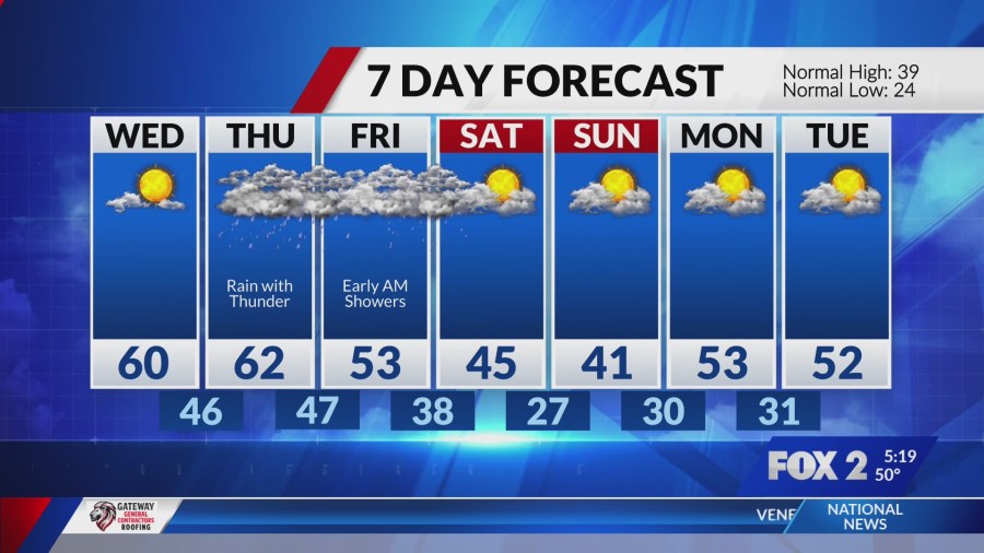
Mild Conditions Persist Through Midweek
A weak cold front moved through the area on Tuesday, yet it failed to disrupt the ongoing mild pattern. Clear skies dominated after initial morning clouds dissipated, allowing highs to climb near 60 degrees Fahrenheit – about 20 degrees warmer than the typical early January average. Residents enjoyed comfortable outdoor activities without the bite of winter winds.
Overnight lows dipped into the upper 30s under mostly clear conditions, setting the stage for another pleasant start on Wednesday. Wake-up temperatures hovered in the low 40s, with sunshine expected to build throughout the day. Winds remained light from the west, preventing any chill from settling in. This respite from colder weather has surprised many, offering a brief taste of spring amid the winter season.
Rain Chances Build for Thursday and Friday
As the week progresses, moisture from an approaching system will introduce rain to the forecast starting Thursday. Expect scattered showers in the morning, intensifying by afternoon with highs still in the upper 50s. The National Weather Service anticipates a 90 percent chance of precipitation, potentially bringing up to half an inch of rainfall to the region.
Friday will continue the wet theme, with showers likely persisting through much of the day and overnight. Lows around 45 degrees will keep conditions above freezing, minimizing any wintry mix concerns. Gusty winds from the south could reach 15 miles per hour, adding to the unsettled feel. While not severe, these rains may lead to slick roads and minor flooding in low-lying areas.
Weekend Outlook and Beyond
Saturday promises a gradual clearing, though isolated showers could linger into the morning. Highs will moderate to the mid-50s under partly cloudy skies, with winds shifting northwest. This transition marks the end of the immediate wet period, allowing drier air to return by Sunday.
Looking further ahead, cooler temperatures in the 40s are possible early next week, closer to seasonal norms. Forecasters from AccuWeather note a low risk of additional rain until midweek, providing opportunities for outdoor plans. Monitoring updates remains key, as systems can shift quickly in winter.
- Tuesday: Mostly sunny, high near 60°F
- Wednesday: Sunny, high in the upper 50s
- Thursday: Rain likely, high around 58°F
- Friday: Showers, high near 55°F
- Saturday: Partly cloudy with possible early showers, high in the mid-50s
Key Takeaways
- Mild highs in the 50s-60s continue through Wednesday, far above average.
- Rain dominates Thursday and Friday, with 90% chances and light accumulation expected.
- Weekend improves with clearing skies and moderating temperatures.
This unusual warm spell in St. Louis highlights the variability of Midwestern winters, reminding us to appreciate the calm before potential changes. As rain approaches, preparing with umbrellas and checking local updates can keep daily routines smooth. What are your plans for these milder days? Share in the comments below.
- Urban Coyotes Show Remarkable Adaptability, Learning to Thrive in City Environments - July 22, 2026
- Beavers Are Nature’s Engineers, Creating Vital Habitats for Other Wildlife Species - July 21, 2026
- The Recovery of the California Condor Offers Hope for Other Critically Endangered Birds - July 21, 2026