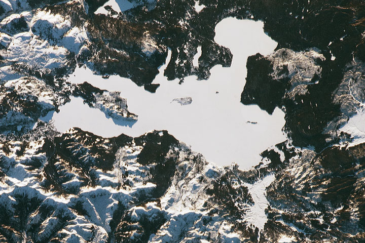
Yellowstone Lake (Image Credits: NASA)
A striking new Earth from space image reveals Yellowstone Lake in Wyoming swathed under an extraordinary blanket of snow, making the natural freshwater expanse appear like a vast, featureless white void from orbit. Captured by an astronaut aboard the International Space Station, this remarkable scene highlights both the power of winter in high-elevation landscapes and the remarkable interplay between surface conditions and deep geothermal activity beneath the lake’s icy crust.
Yellowstone Lake—North America’s largest high-altitude lake at over 7,700 feet above sea level—typically freezes over each winter, but the sheer depth of snow and ice cover seen in this image is exceptional, transforming a once blue and reflective surface into a stark white field that mirrors the surrounding snow-covered terrain. This dramatic seasonal transformation brings into focus not just the region’s winter extremes but also the dynamic processes hidden beneath its frozen surface.
Snow and Ice: A Winter Cloak Over Yellowstone Lake
Each winter, Yellowstone Lake succumbs to freezing temperatures, developing an ice sheet that can reach around two feet in thickness, while snow accumulates even more deeply atop that frozen cap. In some cases, snowdrifts build up to more than three feet, covering nearly all visible water and creating a near-total whiteout that is unmistakable from space.
Taken in late January, the image shows not just uniform snow but subtle undulations and islands—such as Stevenson Island—that punctuate the frozen surface, offering context to how deep snow interacts with the lake’s terrain and ice. From satellite and astronaut vantage points, these patterns underscore how seasonal extremes shape and conceal large inland waters in alpine environments.
A Landscape That Defies Climate Expectations
Despite broader trends in climate warming, Yellowstone Lake’s winter ice and snow cover remain remarkably resilient, often persisting through cold seasons with minimal reduction in overall thickness. In contrast to many high-altitude and high-latitude lakes around the world—where ice cover is shrinking and melt seasons are lengthening—Yellowstone’s lake continues to freeze deeply each year.
Experts believe this persistence stems from a combination of elevation, regional climate patterns, and the lake’s large volume, which together allow sustained winter freeze conditions even as air temperatures trend higher globally. This resilience makes the lake an intriguing case study in how local geography can mitigate broader climate effects, at least seasonally.
Beneath the Ice: Hidden Heat and Life
Belying its icy exterior, Yellowstone Lake harbors active geothermal systems and hydrothermal vents on its floor, releasing water far hotter than typical boiling temperatures due to immense pressure from the overlying water column. Some vents release water measured at temperatures exceeding 345 degrees Fahrenheit, making them among the hottest known in any lake worldwide.
This hidden heat allows aquatic life, including the lake’s native cutthroat trout population, to survive and thrive under the long ice cover despite frigid surface conditions. The dichotomy of an inert snowy surface and a thermally dynamic subsurface speaks to the complexity of ecosystems enduring Yellowstone’s extreme seasonal contrasts.
Seasonal Transformation Visible From Space
The astronaut photo underscores how seasonal conditions can alter our view of familiar landscapes. What is normally an expanse of deep blue water with irregular shorelines becomes a monochrome field of white, illustrating both the harshness of winter and the beauty of Earth’s seasonal rhythms.
Such imagery not only fascinates the public but also offers scientists visual data on snow and ice dynamics, helping researchers monitor changes year over year and better understand how lakes respond to climatic and environmental stresses.
Yellowstone Lake: Geography and Geology
Yellowstone Lake spans roughly 136 square miles and is fed by numerous streams, making it one of the largest high-altitude lakes in North America. Its history is tied deeply to the Yellowstone Caldera—a vast volcanic crater formed by an eruption some 640,000 years ago—which helps explain the region’s geothermal richness.
Beneath the snow and ice, a complex mosaic of geological and hydrological processes continues to shape the lake and its surroundings, from hydrothermal circulation to tectonic forces, offering a living laboratory for understanding Earth’s dynamic systems.
The stunning “white void” image of Yellowstone Lake is more than a seasonal curiosity; it is a testament to the resilience and complexity of Earth’s alpine environments. At first glance, the frozen expanse seems lifeless and stark, yet beneath lie powerful geothermal forces and ecosystems sustained in defiance of surface extremes. In an era of climate uncertainty, Yellowstone Lake reminds us that nature’s rhythms can both endure and astonish, offering critical insights into how landscapes cope with change. While this spectacle delights the eye, it should also inspire deeper scientific engagement—because what appears silent and still on the surface may be dynamic and profound below, revealing layers of Earth’s story that we are only beginning to fully appreciate.
- Urban Coyotes Show Remarkable Adaptability, Learning to Thrive in City Environments - July 22, 2026
- Beavers Are Nature’s Engineers, Creating Vital Habitats for Other Wildlife Species - July 21, 2026
- The Recovery of the California Condor Offers Hope for Other Critically Endangered Birds - July 21, 2026