Earthquakes are nature’s way of reminding us of the dynamic forces that lie beneath the Earth’s surface. These seismic events have not only shaped our physical landscape but have also left indelible marks on the history and development of regions across the United States. In this article, we will journey through some of the most significant earthquakes that have altered the U.S. landscape. From the majestic west coast to the bustling east, these events have reshaped the land and the lives of those who inhabit it.
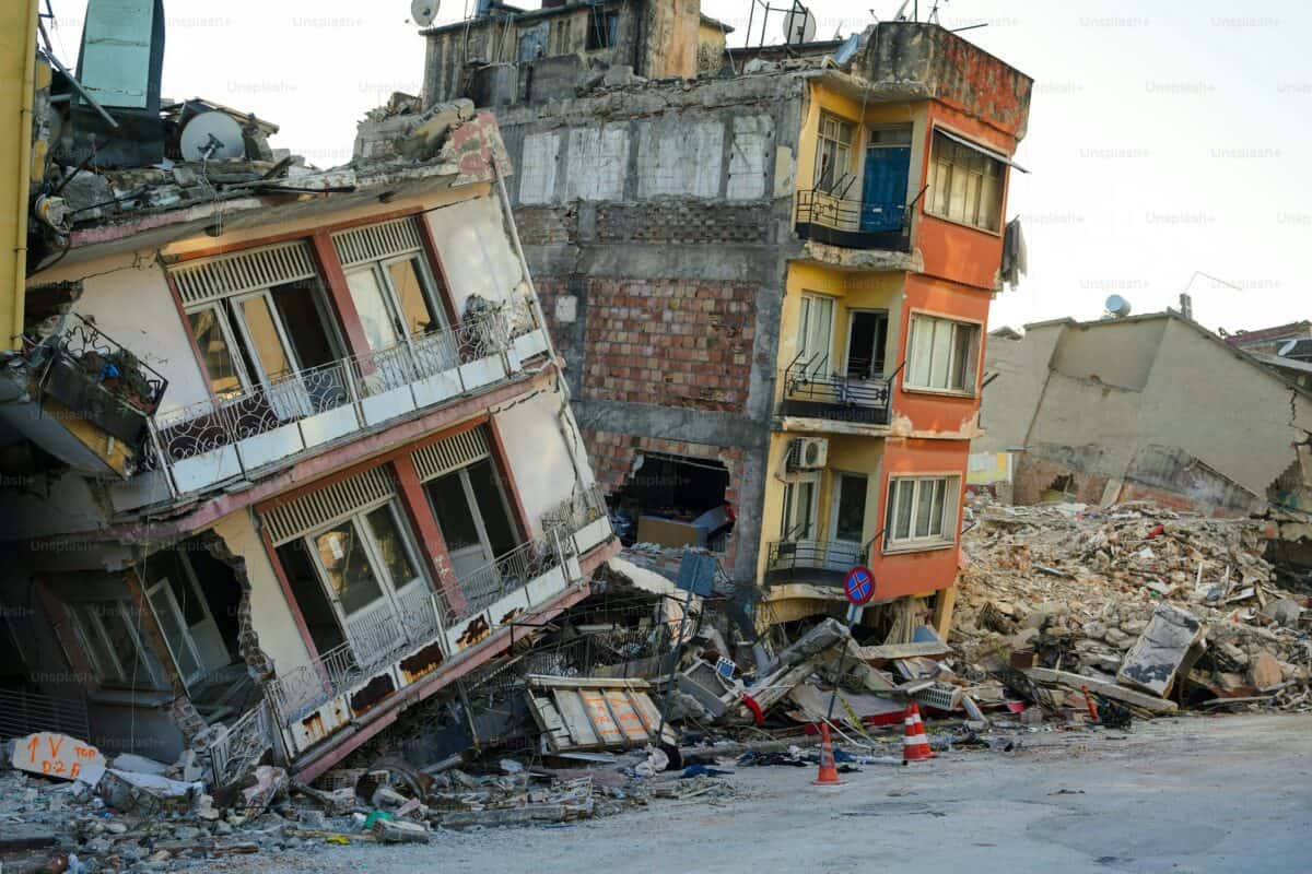
The 1906 San Francisco Earthquake

In the early morning hours of April 18, 1906, San Francisco residents were jolted awake by a violent shaking that would forever change their city. The earthquake, which measured an estimated 7.9 on the Richter scale, was one of the most devastating in U.S. history. It wasn’t just the tremors that wreaked havoc; fires ignited by ruptured gas lines consumed much of the city, leaving tens of thousands homeless. Streets cracked open, buildings crumbled, and the iconic skyline of San Francisco was forever altered. This earthquake highlighted the importance of fire safety and urban planning, as it prompted stricter building codes and a reevaluation of emergency response strategies. The event remains a sobering reminder of the power of nature and the resilience of a city that rose from the ashes.
The 1811-1812 New Madrid Earthquakes

In a part of the country not typically associated with seismic activity, the New Madrid Seismic Zone unleashed a series of powerful earthquakes in the winter of 1811-1812. These quakes were so intense that they caused the Mississippi River to flow backward temporarily and created Reelfoot Lake in Tennessee. The magnitude of these quakes is estimated to have been between 7.0 and 8.0, causing widespread destruction in a sparsely populated region. The tremors were felt as far away as the East Coast, with church bells ringing in Boston and buildings swaying in Washington D.C. These earthquakes served as a stark reminder of the hidden geological threats beneath the heartland of America, influencing future studies and preparedness plans for similar events.
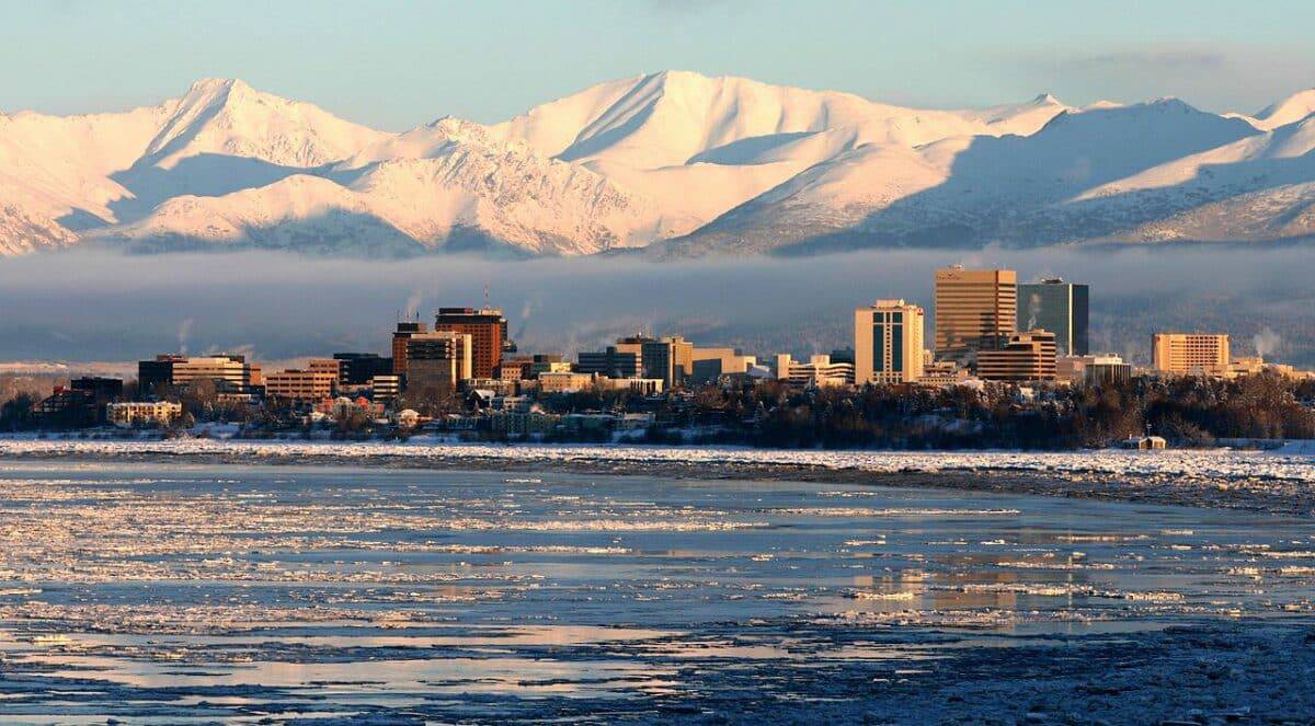
The 1964 Great Alaska Earthquake

On March 27, 1964, Alaska was rocked by the most powerful earthquake ever recorded in North America, measuring a staggering 9.2 on the Richter scale. Known as the Good Friday Earthquake, it lasted nearly four minutes and caused massive tsunamis, landslides, and ground fissures. The landscape was dramatically altered, with entire neighborhoods in Anchorage sinking into the ground and coastal areas experiencing significant uplift. The seismic event claimed over 130 lives and caused extensive damage across the state. It highlighted the vulnerability of infrastructure to natural disasters and led to significant advancements in earthquake engineering and tsunami warning systems. The lessons learned from this earthquake continue to inform safety measures and emergency preparedness in seismic-prone areas.
The 1994 Northridge Earthquake

Southern California was jolted awake in the early hours of January 17, 1994, by a powerful earthquake centered in the San Fernando Valley. The Northridge Earthquake, with a magnitude of 6.7, caused widespread destruction and claimed 57 lives. Freeways collapsed, buildings crumbled, and fires erupted, leaving a trail of devastation in its wake. The quake revealed vulnerabilities in modern infrastructure and prompted significant changes in building codes and construction practices. It also underscored the importance of emergency preparedness and community resilience in the face of natural disasters. The Northridge Earthquake remains a pivotal event in California’s seismic history, reminding residents of the ever-present threat of earthquakes in the region.
The 1989 Loma Prieta Earthquake

Dubbed the “World Series Earthquake” due to its occurrence during the 1989 World Series game in San Francisco, the Loma Prieta Earthquake struck on October 17 with a magnitude of 6.9. The quake caused significant damage to infrastructure, including the collapse of a section of the San Francisco-Oakland Bay Bridge and the Cypress Street Viaduct. The tremors were felt across the Bay Area, causing landslides, fires, and widespread power outages. The event resulted in 63 fatalities and highlighted the need for improved seismic retrofitting of bridges and buildings. It also spurred advancements in earthquake monitoring and early warning systems, enhancing the region’s resilience to future seismic events.
The 1886 Charleston Earthquake

On August 31, 1886, Charleston, South Carolina, experienced one of the most powerful earthquakes to hit the eastern United States. With an estimated magnitude of 7.0, the quake caused widespread destruction in the city, toppling buildings and leaving a lasting impact on the historic architecture. The seismic event was felt as far away as Boston and Chicago, illustrating the wide reach of its tremors. The Charleston Earthquake served as a wake-up call for the eastern U.S., prompting increased awareness of seismic risks in areas not traditionally associated with earthquakes. It also led to the development of building codes and construction practices aimed at minimizing damage from future seismic events.
The 1965 Puget Sound Earthquake

The Pacific Northwest is known for its lush landscapes and towering mountains, but it is also home to significant seismic activity. On April 29, 1965, the Puget Sound region was shaken by a 6.7 magnitude earthquake centered near Seattle, Washington. The quake caused widespread damage to buildings and infrastructure, highlighting the region’s vulnerability to seismic events. It was a stark reminder of the need for preparedness and resilience in the face of natural disasters. The Puget Sound Earthquake spurred research into the Cascadia Subduction Zone, a major fault line that poses a significant threat to the Pacific Northwest. The event also led to improvements in building codes and emergency response strategies, enhancing the region’s ability to withstand future earthquakes.
The 1700 Cascadia Earthquake

Long before modern record-keeping, the Pacific Northwest experienced one of the most powerful earthquakes in U.S. history. On January 26, 1700, the Cascadia Subduction Zone unleashed a massive earthquake with an estimated magnitude of 9.0. The quake caused a tsunami that reached the shores of Japan, illustrating the far-reaching impact of this seismic event. Although no written records exist from the time, geological evidence and Native American oral traditions provide insights into the earthquake’s magnitude and effects. The Cascadia Earthquake serves as a reminder of the potential for catastrophic seismic events in the region and has prompted significant research and preparedness efforts to mitigate future risks.
The 2011 Virginia Earthquake

On August 23, 2011, residents of the eastern United States were startled by a 5.8 magnitude earthquake centered near Mineral, Virginia. The quake was felt from Georgia to Canada, causing minor damage to buildings and infrastructure. The event was a reminder that seismic activity can occur in unexpected places, highlighting the need for preparedness and awareness even in regions not typically associated with earthquakes. The Virginia Earthquake led to increased interest in the study of seismic risks in the eastern U.S., prompting discussions on building codes and emergency response strategies to enhance resilience in the face of future seismic events.
The 2002 Denali Earthquake

Alaska is no stranger to seismic activity, and on November 3, 2002, the Denali Fault unleashed a powerful 7.9 magnitude earthquake. The quake caused significant ground deformation, with sections of the Alaska Highway and the Trans-Alaska Pipeline shifting dramatically. Despite the magnitude of the event, there were no fatalities, thanks in part to the region’s sparse population and the robust construction of critical infrastructure. The Denali Earthquake highlighted the importance of engineering solutions in mitigating the impact of seismic events and underscored the need for ongoing research and preparedness in earthquake-prone areas.
The 1983 Borah Peak Earthquake

On October 28, 1983, Idaho experienced its largest recorded earthquake, a 6.9 magnitude event centered near Borah Peak. The quake caused significant damage to buildings and infrastructure, particularly in the town of Challis. The event resulted in two fatalities and highlighted the seismic risks in the Intermountain West region. The Borah Peak Earthquake prompted increased interest in seismic research and preparedness in Idaho and surrounding states, leading to improvements in building codes and emergency response strategies. The event serves as a reminder of the potential for significant seismic activity in areas not typically associated with earthquakes.
The 1959 Hebgen Lake Earthquake

On August 17, 1959, the Madison Valley in Montana was shaken by a powerful 7.3 magnitude earthquake centered near Hebgen Lake. The quake caused a massive landslide that dammed the Madison River, creating Earthquake Lake. The event resulted in 28 fatalities and caused significant damage to infrastructure in the region. The Hebgen Lake Earthquake highlighted the seismic risks in the Yellowstone area and prompted increased research into the region’s geological activity. The event also underscored the importance of preparedness and resilience in the face of natural disasters, leading to improvements in emergency response strategies and public awareness.
The 1971 San Fernando Earthquake

Southern California is no stranger to earthquakes, and on February 9, 1971, the San Fernando Valley was rocked by a 6.6 magnitude quake. The earthquake caused significant damage to buildings and infrastructure, including the collapse of the Veterans Administration Hospital in Sylmar. The event resulted in 65 fatalities and highlighted the need for improved seismic safety measures in the region. The San Fernando Earthquake led to significant changes in building codes and construction practices, enhancing the resilience of structures to future seismic events. The quake also underscored the importance of emergency preparedness and community resilience in the face of natural disasters.
The 1933 Long Beach Earthquake

On March 10, 1933, the city of Long Beach, California, was rocked by a 6.4 magnitude earthquake. The quake caused significant damage to buildings and infrastructure, particularly in schools, highlighting the need for improved seismic safety measures. The event resulted in 120 fatalities and prompted significant changes in building codes and construction practices across California. The Long Beach Earthquake marked a turning point in seismic safety, leading to the development of the Field Act, which mandated earthquake-resistant construction for schools. The event serves as a reminder of the importance of preparedness and resilience in the face of natural disasters.
The 1872 Owens Valley Earthquake

In the early morning hours of March 26, 1872, the Owens Valley in California was shaken by a powerful earthquake with an estimated magnitude of 7.4. The quake caused significant damage to buildings and infrastructure in the region, highlighting the seismic risks in the Eastern Sierra Nevada. The event resulted in 27 fatalities and underscored the importance of preparedness and resilience in the face of natural disasters. The Owens Valley Earthquake served as a wake-up call for the region, prompting increased research into the area’s geological activity and leading to improvements in building codes and emergency response strategies.
The 1868 Hayward Earthquake

On October 21, 1868, the Hayward Fault in California unleashed a powerful 6.8 magnitude earthquake that caused widespread damage in the San Francisco Bay Area. The quake toppled buildings and left a lasting impact on the region’s infrastructure. The event served as a wake-up call for the Bay Area, highlighting the seismic risks associated with the Hayward Fault and prompting increased research into the region’s geological activity. The Hayward Earthquake also underscored the importance of preparedness and resilience in the face of natural disasters, leading to improvements in building codes and emergency response strategies.
In conclusion, these 14 earthquakes have not only altered the U.S. landscape but have also shaped the nation’s understanding and preparedness for seismic events. As we continue to study and learn from these natural disasters, it is crucial to remember the lessons they have taught us and to remain vigilant in our efforts to mitigate the risks associated with earthquakes.
As a little kid, I fell in love with nature, wildlife, and animals. Living in the USA, South Africa, Italy, China and Germany gave me the opportunity to discover the world's Wildlife. My favorite animals are Mountain Gorillas, Siberian Tigers, and Great White Sharks.
I'm a certified PADI Open Water Diver, went to Everest Base Camp and Trekked Gorillas in Uganda. I hold a Master of Science in Economics and Finance.
Please send any feedback to feedback@animalsaroundtheglobe.com
- The 10 Rarest Dog Breeds Making a Comeback in America - July 19, 2026
- 13 Creatures That Survived Mass Extinctions - July 19, 2026
- 12 Pets That Are Perfect for Seniors - July 19, 2026