
Scientists around the world are closely monitoring what could become one of the most powerful El Niño events ever recorded. New climate forecasts and ocean observations suggest that a rapidly developing warming pattern in the Pacific Ocean may evolve into a rare “Super El Niño,” potentially rivaling or even surpassing some of the strongest events seen since modern records began. Several climate researchers have warned that the phenomenon has the potential to become the strongest El Niño observed in approximately 140 years if current trends continue.
While uncertainty remains over its ultimate strength, major forecasting agencies including the World Meteorological Organization (WMO), NOAA, and international climate centers agree that El Niño conditions are becoming increasingly likely during the second half of 2026. The concern is not simply about warmer ocean temperatures. A Super El Niño can reshape weather patterns across the globe, influencing droughts, floods, heatwaves, tropical storms, agriculture, and even global temperature records.
What Is A Super El Niño?
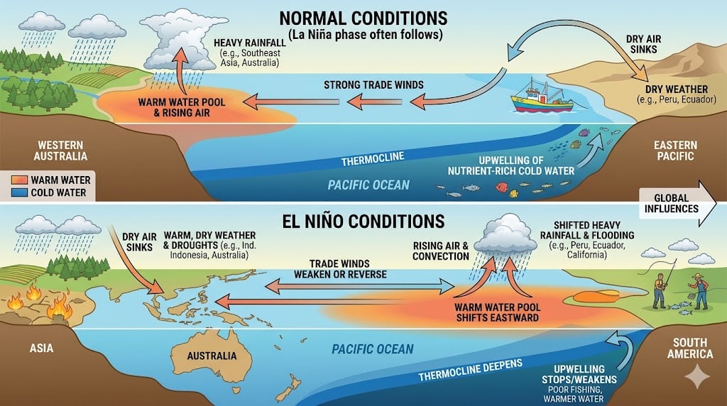
El Niño is a naturally occurring climate phenomenon characterized by unusually warm sea surface temperatures across the central and eastern tropical Pacific Ocean. These warming episodes occur every few years and can significantly alter weather patterns worldwide.
A “Super El Niño” represents the most extreme version of the phenomenon. Scientists generally use the term when Pacific Ocean temperature anomalies exceed approximately 2°C above normal for a sustained period. Such events are relatively rare, occurring only a handful of times during the modern observational era, including major events in 1982-83, 1997-98, and 2015-16. These powerful episodes have historically been associated with severe droughts, devastating floods, agricultural disruptions, and record-breaking global temperatures.
Why Scientists Are Concerned About This Event
The current concern stems from exceptionally rapid warming across key areas of the Pacific Ocean. Climate models have shown unusual agreement in forecasting a strong El Niño, something researchers say is noteworthy given the inherent difficulty of long-range climate prediction.
One factor drawing particular attention is a series of powerful westerly wind bursts across the Pacific. These wind events are helping push enormous amounts of warm water eastward, creating ideal conditions for El Niño intensification. Scientists have also observed a rare pattern involving multiple tropical cyclones that may be accelerating the process. Some projections suggest sea surface temperature anomalies could exceed 2.5°C above average later this year, placing the event firmly within Super El Niño territory.
Researchers emphasize that forecasting El Niño strength remains challenging, especially during the Northern Hemisphere spring when predictive accuracy is often lower. Nevertheless, the growing consensus among international forecasting systems has increased confidence that a major event is developing.
Potential Global Weather Impacts
If the event reaches Super El Niño status, its effects could be felt across multiple continents. Historically, strong El Niños have produced intense rainfall and flooding in parts of North and South America while bringing drought and heat to regions such as Australia, Indonesia, southern Africa, and portions of South Asia.
India, which relies heavily on the southwest monsoon, is particularly vulnerable. Strong El Niño events have often been associated with weaker monsoon rainfall, raising concerns about agriculture, water supplies, and food production. Meanwhile, parts of the western United States could experience wetter-than-normal conditions, while tropical cyclone activity may increase in the Pacific Ocean but decrease in the Atlantic basin.
Climate scientists also warn that extreme heat events could become more frequent and intense. Elevated ocean temperatures release additional heat into the atmosphere, amplifying the effects of ongoing global warming and increasing the likelihood of temperature records being broken.
Could It Trigger New Global Temperature Records?
One of the biggest concerns among researchers is the potential impact on global temperatures. Historically, major El Niño events have been associated with some of the warmest years ever recorded because they transfer large amounts of stored ocean heat into the atmosphere.
Scientists note that this potential Super El Niño would occur against a backdrop of already elevated global temperatures caused by climate change. That combination could push average global temperatures to unprecedented levels. Several forecasts suggest 2027 could challenge or surpass existing global heat records if the event reaches its projected strength. Some climate analysts believe the warming influence of El Niño could linger well into 2027, extending its impacts beyond a single season.
The World Is Watching Closely
The World Meteorological Organization recently reported a high probability that El Niño conditions will develop and persist through much of the year, although the precise peak intensity remains uncertain. Climate agencies are continuing to monitor ocean temperatures, atmospheric conditions, and forecast models for signs of further strengthening.
While scientists caution against declaring a record-breaking event prematurely, the signals emerging from the Pacific Ocean are among the strongest seen in decades. Governments, farmers, emergency managers, and climate researchers are already preparing for the possibility that this could become one of the defining climate events of the decade.
How Will a Super El Niño Impact the U.S.?
If the developing Pacific warming event strengthens into a Super El Niño, the United States could experience significant shifts in weather patterns during late 2026 and early 2027. NOAA currently estimates a 63% chance that this El Niño could become a “very strong” event, potentially ranking among the largest observed since modern records began in 1950. Scientists caution that every El Niño behaves differently, but historical patterns provide a good indication of the most likely impacts.
Potential impacts across the United States include:
- Wetter conditions across the southern U.S. – States stretching from California and Arizona through Texas, the Gulf Coast, and parts of the Southeast often see above-average rainfall during strong El Niño winters, increasing the risk of flooding and mudslides.
- Major storms for California and the West Coast – A stronger Pacific storm track can deliver powerful winter storms, heavy mountain snowfall, and atmospheric river events capable of causing significant flooding.
- Warmer and drier conditions in the northern states – The Pacific Northwest, Northern Rockies, Upper Midwest, and portions of the Great Lakes often experience milder winters and reduced snowfall compared to average years.
- Reduced Atlantic hurricane activity – El Niño typically increases upper-level wind shear across the Atlantic, making it more difficult for hurricanes to develop and strengthen.
- Increased risk of severe weather in parts of the South – A stronger southern jet stream can create favorable conditions for severe thunderstorms and tornado outbreaks during winter and spring.
- Improved drought conditions in parts of the Midwest – Increased rainfall across portions of the Corn Belt and Mississippi Valley could benefit agriculture and reduce drought concerns in some farming regions.
- Higher odds of record-breaking warmth – Because El Niño transfers vast amounts of ocean heat into the atmosphere, it often contributes to some of the warmest years on record globally. Combined with ongoing climate change, forecasters believe 2027 could challenge existing global temperature records.
While a Super El Niño does not guarantee these outcomes in every location, it significantly tilts the odds toward these weather patterns. Meteorologists stress that the event acts as a large-scale climate driver rather than a specific storm system, influencing seasonal weather months in advance. As the Pacific continues to warm, climate agencies around the world are closely monitoring its evolution for signs that one of the strongest El Niño events in modern history may be developing.
Conclusion
The possibility of a Super El Niño developing in 2026 is more than just a scientific curiosity. It represents a potential global weather disruptor capable of influencing rainfall, agriculture, wildfire risk, water supplies, and temperatures across much of the planet. Although uncertainties remain, the growing agreement among climate models has elevated concerns that the world could soon experience one of the strongest El Niño events in modern history.
Whether it ultimately becomes the strongest event in 140 years remains to be seen. But the message from climate scientists is increasingly clear: the Pacific Ocean is sending powerful signals, and the world would be wise to pay attention.