Fresno County, California – Residents in California’s agricultural heartland encountered an uncommon weather spectacle on Tuesday when two tornadoes briefly touched down amid a powerful Pacific storm system. The National Weather Service confirmed the events, issuing urgent warnings that prompted schools to shelter students and drivers to seek cover.[1][2] No injuries occurred, and damage remained limited, but the incidents underscored the state’s occasional vulnerability to severe thunderstorms.
Sudden Warnings Disrupt Afternoon Routine
The first signs of trouble emerged around 2:12 p.m. when a resident reported a funnel cloud touching down near Biola, a small community nine miles west of Fresno. Law enforcement soon confirmed the tornado on the ground, prompting the National Weather Service’s Hanford office to issue a tornado warning for parts of Fresno and Madera counties.[1][3] The twister moved northeast at about 15 miles per hour, crossing paths near Highway 99 south of Madera.
Skies darkened rapidly over the region as hail pelted the ground and winds intensified. The warning, which highlighted risks of flying debris and damage to roofs and vehicles, lasted until around 2:45 p.m. before the storm appeared to lift. Clovis Unified School District instructed students to shelter in place during the alert.[2]
First Tornado’s Brief but Intense Path
Nick Daer, a meteorologist with the National Weather Service in Hanford, noted that the initial report came from a local resident spotting the funnel cloud near Biola. The tornado stayed aloft for up to 10 minutes, fueled by a moist environment created by morning rains followed by afternoon warming.[1] Forecasters tracked the storm cell as it produced heavy rain and gusty winds.
By 2:49 p.m., officials described a severe thunderstorm capable of spawning another tornado near Bonadelle Ranchos-Madera Ranchos, eight miles northwest of Fresno. The system continued northeast, but the immediate threat dissipated shortly before 3 p.m. No major structural damage surfaced from this event.
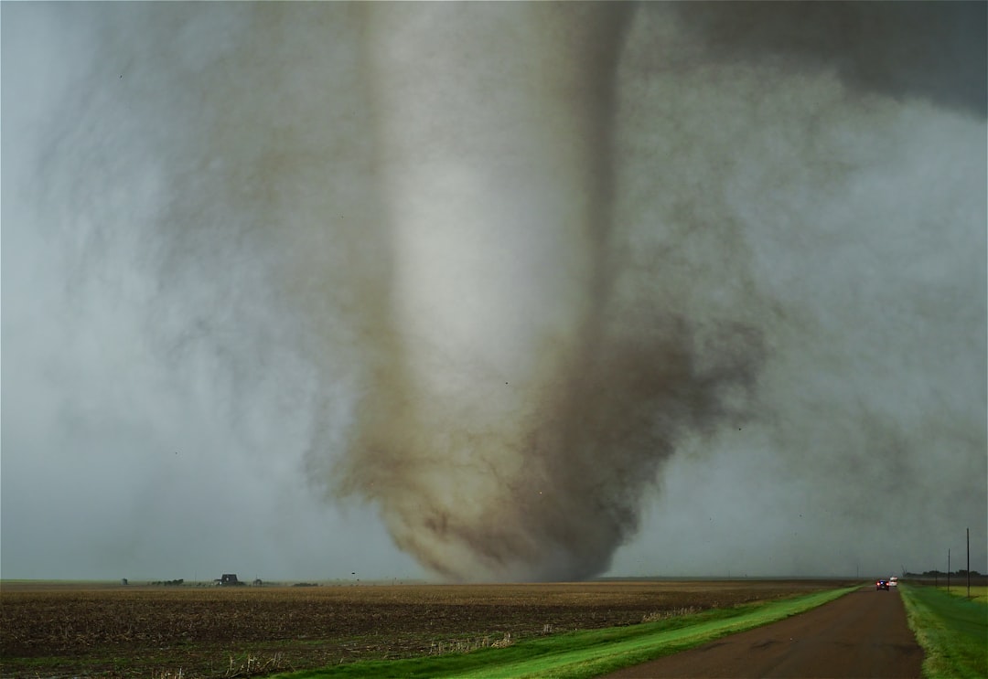
Second Twister Adds to the Rarity Hours Later
Relief proved short-lived. Around 5:15 p.m., a second tornado formed nine miles northeast of Clovis, near Auberry and Tollhouse, roughly 35 miles northeast of Fresno. Residents reported the touchdown, and the National Weather Service rated it preliminarily as an EF1 with winds between 86 and 110 miles per hour.[2] It moved northeast at 20 miles per hour.
A fresh tornado warning urged immediate shelter until 5:45 p.m., warning of potential destruction to mobile homes and tree damage. Survey teams later found snapped and uprooted trees consistent with EF1 strength. The storms then pushed into the mountains, where a winter storm warning lingered until Wednesday evening.[3]
Uncommon Fury in a Tornado-Light State
Tornadoes rarely plague California, with only 487 recorded statewide since 1950 according to Golden Gate Weather Services data. The Fresno area’s last notable event occurred on January 16, 2019, in Clovis, also an EF1 twister.[1] Spring marks the peak season for such activity in the Central Valley.
Brian Ochs, another Hanford meteorologist, explained the confirmation process: “We can’t officially call it a tornado until we get additional information.” A Pacific storm system delivered the unstable setup, blending coastal rain, Sierra snow, and Central Valley thunderstorms enhanced by warmer ocean waters.[1]
- Moist low-level air from recent rains
- Afternoon heating after partial clearing
- Strong wind shear from the approaching front
- Hail and heavy rain as precursors
Swift Response Limits Harm
Authorities reported no injuries and no widespread destruction immediately after both touchdowns. Sporadic issues included broken tree branches, downed trees damaging cars, and possible power pole concerns. Fresno County Sheriff’s Office confirmed the lack of major impacts.[2]
National Weather Service teams conducted damage surveys promptly, aiding future ratings. The events echoed a weak EF0 tornado in Los Angeles’ Boyle Heights last December, reminding Californians of the state’s subtle severe weather risks.[4]
| Tornado Event | Time | Location | Strength/Impacts |
|---|---|---|---|
| First | 2:12-2:20 p.m. | Near Biola | Brief touchdown; hail, winds |
| Second | 5:15 p.m. | NE of Clovis | EF1 preliminary; tree damage |
Key Takeaways
- Two tornadoes confirmed in one day mark a rare occurrence for Fresno County.
- Quick warnings prevented injuries despite proximity to populated areas.
- Climate patterns may increase such events; stay alert to NWS alerts.
These tornadoes served as a stark reminder that even California’s mild climate harbors surprises. As cleanup wraps up and surveys conclude, locals reflect on the close call. What do you think about these unusual weather patterns? Tell us in the comments.
- Urban Coyotes Show Remarkable Adaptability, Learning to Thrive in City Environments - July 22, 2026
- Beavers Are Nature’s Engineers, Creating Vital Habitats for Other Wildlife Species - July 21, 2026
- The Recovery of the California Condor Offers Hope for Other Critically Endangered Birds - July 21, 2026