
Picture this: it’s a seemingly ordinary Monday evening in early May 1999, and families across Oklahoma City are settling in for dinner. The sky is growing dark, but not from the approaching sunset. What’s barreling toward the metro area would forever change how we understand the raw, terrifying power of nature’s most violent storms.
The events that unfolded on May 3, 1999, would shatter records, claim dozens of lives, and leave a billion-dollar trail of destruction in their wake. This wasn’t just another tornado; it was a meteorological monster that would earn the distinction of being the strongest tornado ever documented to strike the Oklahoma City metropolitan area.
The Birth of a Monster
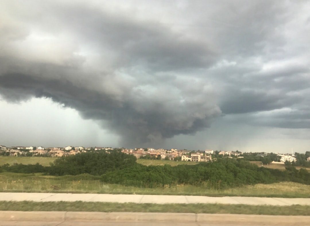
The tornado first touched down at 6:23 p.m. Central Daylight Time in Grady County, roughly two miles south-southwest of the town of Amber. What started as a relatively modest weather disturbance would rapidly transform into something truly unprecedented. The atmospheric conditions were primed for disaster that day, with meteorologists tracking an unstable air mass that had been building throughout the afternoon.
Within minutes of touching down, the tornado quickly intensified into a violent F4, and gradually reached F5 status after traveling 6.5 miles, at which time it struck the town of Bridge Creek, where parts of the community were rendered unrecognizable. The speed at which this storm gained strength was unlike anything researchers had witnessed before.
Record-Breaking Wind Speeds

The 1999 Bridge Creek-Moore tornado was a large, long-lived, and exceptionally violent F5 tornado in which the highest tornado wind speed ever measured with a doppler radar was recorded at 301 mph (±20 mph) by a Doppler on Wheels. These wind speeds weren’t just impressive; they were literally off the charts of what scientists thought possible for atmospheric phenomena on Earth.
The mobile Doppler radar measurement of 301 mph (±20 mph) makes it the strongest tornado wind speed ever recorded. To put this in perspective, these winds were nearly twice as fast as Category 5 hurricanes, the most intense tropical cyclones on the planet. The sheer force involved was enough to level well-built structures and turn everyday objects into deadly projectiles traveling at unimaginable speeds.
A Path of Unprecedented Destruction
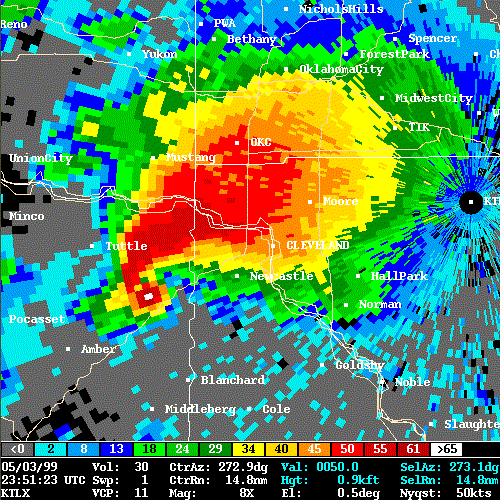
The tornado covered 38 miles during its approximately 90-minute existence, destroying thousands of homes, and the max width was 1 mile. The storm’s path cut a devastating swath through some of Oklahoma’s most densely populated areas. It fluctuated in strength, ranging from F2 to F5 status before it crossed into Cleveland County where it reached F5 intensity for a third time shortly before entering the city of Moore. By 7:30 p.m., the tornado crossed into Oklahoma County and battered southeastern Oklahoma City, Del City, and Midwest City before dissipating around 7:48 p.m. just outside Midwest City.
In Bridge Creek, damage was among the most extreme ever documented as many homes were swept away completely, leaving only concrete slabs where the structures once stood. Damage surveyors noted that the remaining structural debris from some of the homes in this area was finely granulated into small fragments, and that trees and shrubs were completely debarked. The tornado essentially erased entire neighborhoods from existence.
A Historic Warning System Response

Its severity prompted meteorologist Rick Smith at the Norman National Weather Service office to issue an unprecedented emergency statement, though this was not yet an official NWS product. This wasn’t just another tornado warning; it was meteorologists desperately trying to convey to the public that something extraordinary and deadly was approaching. The emergency broadcast stated: “A LARGE TORNADO WAS MOVING ALONG INTERSTATE 44 WEST OF NEWCASTLE. ON ITS PRESENT PATH…THIS LARGE DAMAGING TORNADO WILL ENTER SOUTHWEST SECTIONS OF THE OKLAHOMA CITY METRO AREA BETWEEN 7:15 AND 7:30 PM. PERSONS IN MOORE AND SOUTH OKLAHOMA CITY SHOULD TAKE IMMEDIATE TORNADO PRECAUTIONS! THIS IS AN EXTREMELY DANGEROUS AND LIFE THREATENING SITUATION. IF YOU ARE IN THE PATH OF THIS LARGE AND DESTRUCTIVE TORNADO…TAKE COVER IMMEDIATELY”.
There had never been a tornado emergency issued before – it was not an official National Weather Service product, nor was it something that had ever been discussed – but it clearly established the stakes. There was no stopping what was coming, and every decision carried grave consequences for the many thousands of people still in the path.
The Human Cost

Thirty-six people were killed as a direct result of the storm and five more died of indirect causes in the hours following it; most of the indirect deaths were due to heart attacks or injuries suffered while trying to seek shelter. There were 583 injuries. Twelve people died in Bridge Creek, nine of whom were in mobile homes; all fatalities and the majority of injuries were concentrated in the Willow Lake and Southern Hills Additions and Bridge Creek Estates, consisting mostly of mobile homes. Over 39 people were injured in the area as well.
Some of the most severe damage took place in Cleveland County, mainly in Moore, where 11 people were killed and 293 others were injured. The tornado caused an estimated $450 million in damage across the county. The tragedy was made even more heartbreaking by the fact that many victims were families simply trying to weather the storm in their homes.
Financial Impact and Recovery

The tornado caused US$1 billion in damage, ranking it as the fifth-costliest on record not accounting for inflation. The destruction included 1800 homes destroyed, and 2500 homes damaged. This wasn’t just numbers on a balance sheet; these were entire communities that had to be rebuilt from nothing.
A major disaster declaration was signed by President Bill Clinton the following day allowing the state to receive federal aid. In the following months, disaster aid amounted to $67.8 million. Reconstruction projects in subsequent years led to a safer, tornado-ready community. The rebuilding effort became a testament to human resilience and the determination to create safer structures that could better withstand future storms.
The 1999 Bridge Creek-Moore tornado stands as a sobering reminder of nature’s incredible power and unpredictability. Though technology and warning systems have improved significantly since then, this historic storm continues to inform how meteorologists track severe weather and how communities prepare for the worst. The legacy of that terrible Monday evening lives on not just in the rebuilt neighborhoods, but in the enhanced safety measures that have undoubtedly saved countless lives in subsequent years.
What strikes you most about this incredible display of nature’s raw power? The fact that winds can reach over 300 mph, or that an entire community can be rebuilt stronger than before? Tell us what you think in the comments below.
- The Zodiac Signs That Cats Choose as Their Favorite Person (And Why They Ignore Everyone Else) - June 23, 2026
- What It Means When You See a Blue Jay at Your Window Every Morning (The Pattern Ornithologists Finally Explain) - June 23, 2026
- 10 Popular Garden Birds in North America and How to Ensure They Keep Returning - June 23, 2026