
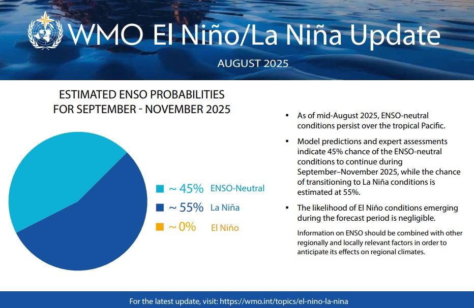
Forecasters are sounding the alarm that La Niña conditions are increasingly likely to take hold as early as October, with probabilities climbing toward 80 percent through December. According to the Climate Prediction Center, sea surface temperatures across the central and eastern Pacific are cooling rapidly, while the atmosphere is beginning to respond with stronger easterly trade winds and shifting rainfall patterns. The National Oceanic and Atmospheric Administration’s (NOAA) Climate Prediction Center (CPC) has issued a La Niña Watch with the CPC forecasting a 71% chance of La Niña conditions developing between October and December 2025, transitioning from the current ENSO-neutral phase.
Taken together, these signals point toward the return of La Niña, a climate phenomenon that can dramatically reshape weather patterns across the United States. Experts caution that while this event may not reach the strength of historic La Niñas, its timing could influence everything from regional drought to snowpack vital for water resources.
What La Niña Actually Means

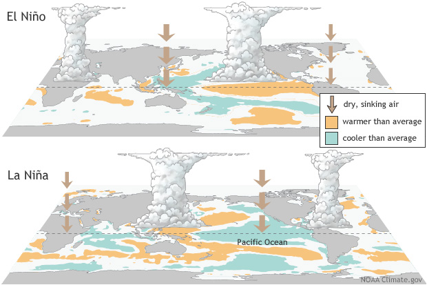
La Niña is the cooler counterpart to El Niño, both phases of the broader El Niño–Southern Oscillation. It develops when ocean temperatures in the equatorial Pacific drop below average for several consecutive months, altering global circulation patterns. In a weak to moderate La Niña, which most forecasters currently expect, the influence can still be far-reaching.
The jet stream tends to shift northward, allowing colder air to spill into the northern U.S. while suppressing storm activity in the south. Though the phenomenon is ocean-driven, its effects ripple through the atmosphere, shaping how cold, wet, or dry different regions of the country will become.
Cooler North, Warmer South on the Horizon
If La Niña locks in this fall, the most immediate impact will likely be seen in temperatures across the country. The northern tier of the U.S.—including the Pacific Northwest, the northern Rockies, and the upper Midwest—could face cooler-than-average conditions, particularly as winter approaches.
At the same time, the southern states are more likely to remain warmer, with mild winters expected across the Gulf Coast, Florida, and much of the Southwest. While these patterns match the historical footprint of La Niña, forecasters stress that each event has its own quirks, and regional outcomes can differ based on the strength of the cooling.
Shifting Rainfall and Storm Tracks
La Niña also has a profound effect on precipitation. In many years, storm systems are nudged northward, bringing wetter conditions to the Pacific Northwest and parts of the northern Plains. This could mean heavier rainfall and increased chances of flooding in river basins already primed with moisture. In contrast, the southern U.S.—stretching from Arizona and New Mexico through Texas and into the Southeast—typically sees drier conditions.
For these regions, a weak La Niña could worsen existing drought, limit reservoir replenishment, and stress agricultural production. The altered storm tracks will be critical to watch, as even small shifts can change which states end up wetter or drier than expected.
Winter Snowfall and Cold Outbreaks
Snowfall is another factor likely to be influenced by La Niña. Northern states, especially around the Great Lakes, the northern Rockies, and the Cascades, may experience more frequent snow events if colder air aligns with active storm tracks. These regions could benefit from increased snowpack, which helps with spring runoff and water supplies.
Meanwhile, the southern states are expected to see fewer winter storms, with precipitation more likely to fall as rain rather than snow. A weaker La Niña might not deliver the kind of blockbuster snow years seen in stronger episodes, but it can still set the stage for above-average totals in northern and mountainous areas.
Regional Stakes: Who Will Feel It Most
For some regions, the return of La Niña is a double-edged sword. The Pacific Northwest and northern California may see welcome rainfall, but that relief also carries the risk of flooding and landslides. Arizona and New Mexico, on the other hand, are bracing for the prospect of a drier winter, which could exacerbate wildfire risks and prolong water shortages.
The Southeast, too, may suffer from a lack of rainfall, leaving farmers vulnerable. In contrast, states like Wisconsin, Minnesota, and Montana could endure harsher winters, with colder temperatures and heavier snow than their southern counterparts.
Uncertainty and Broader Implications

Despite the mounting evidence, forecasters are quick to stress that uncertainty remains. This year’s La Niña is likely to be weak to moderate, meaning its effects may be less predictable than a strong event. Other climate factors, such as the Arctic Oscillation or Pacific Decadal Oscillation, could reinforce or counteract the expected patterns. What is certain, however, is that communities must prepare for a season of contrasts—colder and snowier in the north, warmer and drier in the south.
From energy demand to agriculture, water management to disaster preparedness, the implications of La Niña will be felt across the nation well beyond the Pacific Ocean where it begins.