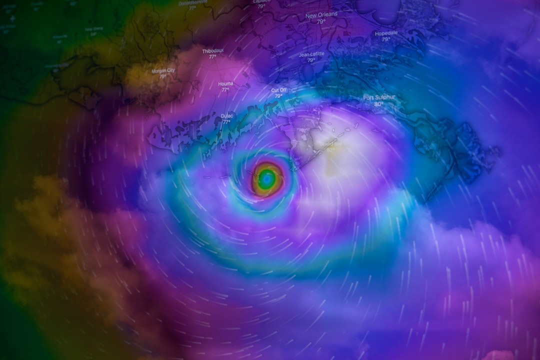

A Storm Takes Shape in the Deep Tropics (Image Credits: Unsplash)
Leeward Islands – Swirling bands of rain stretch across the Atlantic, hinting at the growing power of a storm that’s about to test the region’s resilience under darkening skies.
A Storm Takes Shape in the Deep Tropics
Picture this: just days ago, a cluster of thunderstorms in the central Atlantic caught forecasters’ eyes, and by Tuesday morning, it had organized enough to earn the name Jerry, marking the tenth named storm of the 2025 season. That’s later than average for this point in the year, but Jerry wasted no time ramping up. Now, with sustained winds hitting 65 mph, it’s barreling west-northwest at around 18 mph, closing in on the northern Leeward Islands.
What’s striking here is how quickly things evolved from a vague disturbance to a full-fledged tropical storm. Satellite views show a lopsided system, with heavy thunderstorms pushed to one side by upper-level winds. Still, models suggest Jerry has a shot at hurricane status soon, adding urgency to preparations across the islands.
Shear and Speed: The Forces Shaping Jerry’s Path
Vertical wind shear is playing a big role right now, tearing at Jerry’s structure and keeping its center somewhat exposed amid those towering clouds. This isn’t ideal for rapid growth, yet the storm pushes forward relentlessly. Forecasters note that shear should ease just enough over the next couple of days to let Jerry pack more punch as it nears land.
Moving at a brisk clip, Jerry covers ground fast, which means the northern Leewards could feel its outer bands by Thursday afternoon. Tropical storm watches cover places like Antigua, Montserrat, and St. Kitts, while warnings are up for Anguilla, Barbuda, and Sint Maarten. Expect gusty winds up to 50-60 mph, along with heavy downpours that could dump several inches of rain.
Impacts on the Horizon for the Northern Leewards
Residents from the U.S. and British Virgin Islands to Guadeloupe are hunkering down as Jerry’s closest approach unfolds tonight and into Friday. The forecast track keeps the storm’s core just offshore to the east, which is a relief – no direct hit expected. But that doesn’t mean smooth sailing; rough seas, coastal flooding, and power outages remain real risks.
Local officials urge people to secure outdoor items, stock up on essentials, and avoid low-lying areas. Flash flooding poses the biggest threat in urban spots, where even a few hours of intense rain can overwhelm drains. One silver lining: the storm’s speed might limit how long these conditions linger, potentially wrapping up by early Saturday.
Beyond the Islands: Jerry’s Next Moves
Once Jerry brushes past the Leewards, steering currents should nudge it northward by Friday, steering clear of Puerto Rico and the Bahamas. That’s when things could get interesting – models predict strengthening to hurricane force, with winds possibly topping 74 mph. Bermuda, still recovering from Hurricane Imelda’s punch last week, might need to watch closely as the storm arcs that way early next week.
This northward turn fits a pattern we’ve seen all season. A beefed-up Azores High is acting like a traffic cop, shoving storms out to sea before they eye the U.S. East Coast. It’s why most Atlantic systems this year have stayed offshore, sparing the mainland but keeping island communities on edge.
Lessons from Past Jerrys: History Repeating?
Jerry isn’t a new face on the storm lists – it debuted back in 1983 and has spun up seven times since, often as a mid-season player. Take 2019: that Jerry mirrored today’s path, skirting the Leewards as a strengthening storm before fading in the open Atlantic. Current forecasts echo that trajectory, suggesting 2025’s version could wrap up similarly, far from major landmasses.
Yet each storm brings its twists. Unlike some predecessors, this Jerry faces a slightly cooler pool of water ahead, which might cap its intensity. Tracking these parallels helps experts refine predictions, but locals know better than to bet on history alone – preparation trumps patterns every time.
Quiet Waters Ahead in the Atlantic Basin
With Jerry grabbing the spotlight, the rest of the Atlantic looks calm for now, at least through the weekend. No immediate threats loom for the Caribbean or Gulf, giving a brief breather to areas still mopping up from earlier storms like Humberto. That said, the season’s far from over; warm waters persist, and another disturbance near the Azores has a slim chance of stirring.
Next in line for a name? Karen, another holdover from those early lists. Forecasters aren’t sounding alarms yet, but the tropics can flip fast. Keeping an eye on satellite feeds and updates from the National Hurricane Center remains key for anyone in the region.
In the end, Tropical Storm Jerry serves as a stark reminder of the Atlantic’s unpredictable moods – powerful enough to disrupt but often merciful in its misses. As it grazes the Leewards tonight, the focus stays on safety and swift recovery. What’s your take on this season’s wild rides so far? Share in the comments below.
Key Takeaways
- Jerry could reach hurricane strength after passing the Leewards, but impacts there stay at tropical storm levels.
- Northern islands face winds, rain, and flooding risks tonight through Friday morning.
- Bermuda and the open Atlantic are next in the storm’s potential path, influenced by a strong Azores High.
From exploring the marine wonders in the Azores and witnessing the vast savannas of Kenya, to delving deep into the rich biodiversity of South Africa and traversing iconic landscapes in Australia and the US like Yellowstone, Chris's experiences are vast.
With a penchant for diving alongside sharks, the ocean holds a special place in his heart.
Through his academic insights, he champions wildlife conservation, striving with 'Animals Around The Globe' to cultivate a profound connection between humans and animals, enhancing our mutual appreciation.
Connect with him at Feedback@animalsaroundtheglobe.com.
- Spirit Animals: What Yours Means and How to Find It - July 31, 2026
- Why the World’s Loudest Animals Are Going Quiet - July 31, 2026
- This Animal Produces the Loudest Mating Call on Earth - July 31, 2026