
The Fury from Above (Image Credits: Cdn.mos.cms.futurecdn.net)
Victoria, Australia – Advanced satellite technology has delivered haunting images of the bushfires tearing through southeastern landscapes, highlighting the fires’ relentless spread and widespread destruction.
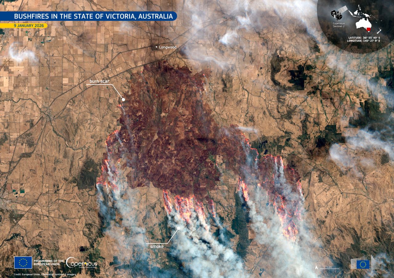
The Fury from Above
Recent imagery from the Copernicus Sentinel-2 satellite revealed the sheer magnitude of the blazes consuming vast areas in Victoria. The photos, captured earlier this week, showed thick plumes of smoke billowing across the region, obscuring the terrain below. Fire fronts stretched for miles, leaving charred expanses in their wake. Authorities reported that these fires had already scorched more than 400,000 hectares of land by mid-January. The satellite data underscored how quickly the situation escalated amid dry conditions and strong winds.
Experts noted that the images provided a critical overview that ground-level observations could not match. The European Union’s Copernicus program, which operates the Sentinel satellites, emphasized the role of such technology in monitoring environmental disasters. This particular snapshot, taken on January 11, illustrated burn scars that rivaled the size of small cities. Response teams used these visuals to prioritize containment efforts in the most affected zones.
Understanding the 2025-26 Bushfire Season
The current bushfire season began with warnings from the Australasian Fire Authorities Council in late 2025. Officials predicted heightened risks in southwestern and central Victoria, along with parts of Western Australia and New South Wales. By early January 2026, those forecasts proved accurate as multiple outbreaks merged into larger infernos. The fires not only threatened homes but also disrupted daily life across rural communities. Evacuations became necessary in several areas as flames approached populated zones.
Historical patterns showed that bushfires in Australia often peak during summer months, but this season arrived with unusual intensity. Climate experts linked the severity to prolonged droughts and record heatwaves recorded in 2025. Satellite monitoring helped track fire progression over days, revealing how smoke traveled far beyond the fire lines. In one instance, plumes drifted across state borders, affecting air quality in neighboring regions. The data also aided in assessing regrowth potential for damaged ecosystems.
Technological Aids in Fire Management
Satellites like those in the Copernicus and JPSS programs offered real-time insights that transformed firefighting strategies. Imagery from polar-orbiting satellites detected hotspots invisible from the ground, allowing crews to deploy resources efficiently. For example, multi-day sequences showed fires expanding in the Northern Territory and Queensland, guiding aerial water drops and backburn operations. These tools proved invaluable during the height of the crisis, when visibility on the ground dropped to near zero.
Beyond detection, the technology supported broader environmental analysis. Researchers used the images to measure smoke dispersion and its impact on atmospheric conditions. One key benefit involved mapping unburned corridors to protect wildlife habitats. International collaboration enhanced this effort, with data shared among agencies worldwide. Overall, satellite contributions reduced response times and saved lives in vulnerable areas.
Human and Ecological Impacts
The bushfires displaced thousands and destroyed over 130 structures, including homes and outbuildings. Communities in Victoria’s Gippsland region faced the brunt, with Premier announcing a fundraising appeal to aid recovery. Five fatalities marked the season’s tragic toll by early January. Smoke from the fires prompted health warnings, as fine particles affected respiratory systems across southeastern Australia. Agricultural losses compounded the hardship, with livestock and crops suffering extensive damage.
Ecologically, the blazes altered habitats for native species, many of which relied on periodic fires for regeneration. Satellite views captured the contrast between vibrant pre-fire landscapes and the barren aftermath. Conservation groups highlighted the need for resilient planting in recovery plans. Long-term, these events served as a reminder of Australia’s vulnerability to extreme weather. Efforts to rebuild focused on fire-resistant infrastructure and community preparedness programs.
- Over 400,000 hectares burned in Victoria alone.
- Smoke plumes visible from space, extending hundreds of miles.
- Five lives lost in the 2025-26 season so far.
- More than 130 structures destroyed statewide.
- Satellite data enabled faster evacuation alerts.
- Increased fire risk predicted for central Victoria.
Key Takeaways
- Satellite imagery from Copernicus Sentinel-2 provides unprecedented detail on fire spread and smoke patterns.
- Bushfires this season have exceeded early warnings, emphasizing the role of climate trends.
- Technological monitoring integrates with ground efforts to mitigate future risks.
As the fires continue to challenge Australia’s resilience, these orbital perspectives remind us of nature’s power and humanity’s ingenuity in response. What steps can communities take to better prepare for such events? Share your thoughts in the comments.
As a little kid, I fell in love with nature, wildlife, and animals. Living in the USA, South Africa, Italy, China and Germany gave me the opportunity to discover the world's Wildlife. My favorite animals are Mountain Gorillas, Siberian Tigers, and Great White Sharks.
I'm a certified PADI Open Water Diver, went to Everest Base Camp and Trekked Gorillas in Uganda. I hold a Master of Science in Economics and Finance.
Please send any feedback to feedback@animalsaroundtheglobe.com
- 11 Most Endangered Insects Buzzing in America Today - July 22, 2026
- 10 Most Frequently Googled Animal Birth Facts - July 22, 2026
- 10 Incredible Migration Journeys in the Animal Kingdom - July 22, 2026