Monday’s Relentless Cold Front (Image Credits: Fox2now.com)
St. Louis – Biting winds and subfreezing wind chills marked the start of the workweek in the Gateway City, offering a stark reminder of winter’s lingering grip.[1][2]
Monday’s Relentless Cold Front
Residents awoke to morning temperatures in the teens, where wind chills plunged close to zero degrees. Gusty northwest winds whipped through the region, amplifying the chill factor early in the day. Skies gradually cleared as the morning progressed, providing some visual relief amid the discomfort.
Winds began to subside around lunchtime, allowing afternoon highs to climb modestly into the low 30s. Such conditions demanded layered clothing and caution for anyone venturing outdoors, particularly during the commute. The cold air mass responsible for this snap held firm through the day, keeping comfort levels low.[1]
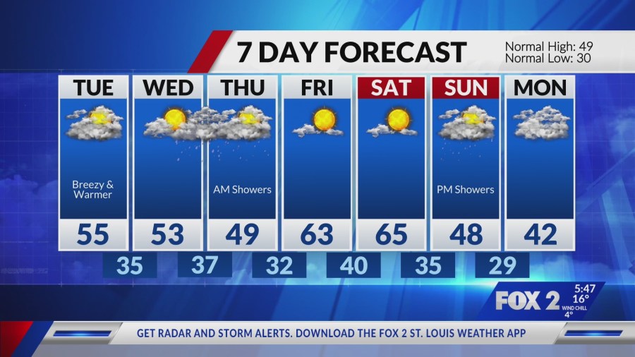
Tuesday’s Turn to Milder Air
A shift in wind direction brought noticeable improvement by Tuesday morning. Wake-up temperatures rose into the 20s, setting a less harsh tone. Southwest breezes picked up, carrying warmer air into the area under a layer of cloud cover.
Afternoon highs reached the mid-50s, a significant jump from Monday’s lows. The breezy conditions persisted but felt invigorating rather than punishing. This transition highlighted the region’s volatile winter weather patterns, where rapid changes keep forecasters busy.[2]
Wednesday Offers a Brief Respite
The middle of the week promised the most pleasant stretch. Quiet weather dominated Wednesday, with comfortable highs lingering in the 50s. Partly cloudy skies prevailed through much of the day, ideal for outdoor activities.
Clouds thickened toward evening, signaling the approach of unsettled weather. Still, the day stood out as a welcome break from extremes. Residents could finally shed heavier coats without regret.
Storms Loom for Thursday
Rain and storms arrived late Wednesday night, continuing into Thursday. The system ushered in a slight cool-down afterward, tempering the recent warmth. Expect scattered showers and possible thunder, typical for such fronts in the Midwest.
Friday and Saturday looked poised for another rebound, with temperatures climbing higher once more. The extended outlook suggested a pattern of ups and downs, common this time of year.
| Day | High Temp | Key Conditions |
|---|---|---|
| Monday | Low 30s | Gusty NW winds, clearing skies |
| Tuesday | Mid 50s | Cloudy, SW breezes |
| Wednesday | 50s | Quiet, increasing clouds |
| Thursday | Cooler | Rain and storms |
- Layer up for Monday’s wind chills near zero.
- Enjoy mid-50s highs Tuesday, but watch for breezes.
- Wednesday delivers comfort before rain returns.
- Plan indoor alternatives for Thursday storms.
- Warmer weekend ahead – perfect for early spring outings.
Key Takeaways:
- Coldest morning of the week hits Monday with teens and near-zero feels-like temps.
- Quickest warm-up occurs Tuesday, surging to mid-50s.
- Rain risks rise Thursday, cooling things briefly.
St. Louis weather delivered its classic variability this week, swinging from deep freeze to thaw in mere days. Keep an eye on updates as systems evolve. What do you think about this rollercoaster forecast? Tell us in the comments.
- Urban Coyotes Show Remarkable Adaptability, Learning to Thrive in City Environments - July 22, 2026
- Beavers Are Nature’s Engineers, Creating Vital Habitats for Other Wildlife Species - July 21, 2026
- The Recovery of the California Condor Offers Hope for Other Critically Endangered Birds - July 21, 2026