The ground beneath the United States is far less stable than most people imagine. While daily life rolls along without a tremor in most cities, the earth is quietly accumulating stress along a network of ancient fractures, some well-known, others buried invisibly beneath densely populated neighborhoods. Fault lines are not a West Coast problem. They cross the heartland, cut beneath major cities, and stretch along coastlines that have never seen a major quake in recorded history.
What makes certain faults genuinely dangerous isn’t just their size. It’s the combination of how much stress they’ve stored, how long they’ve been silent, and how many millions of people live right on top of them. The picture, when laid out clearly, is sobering.
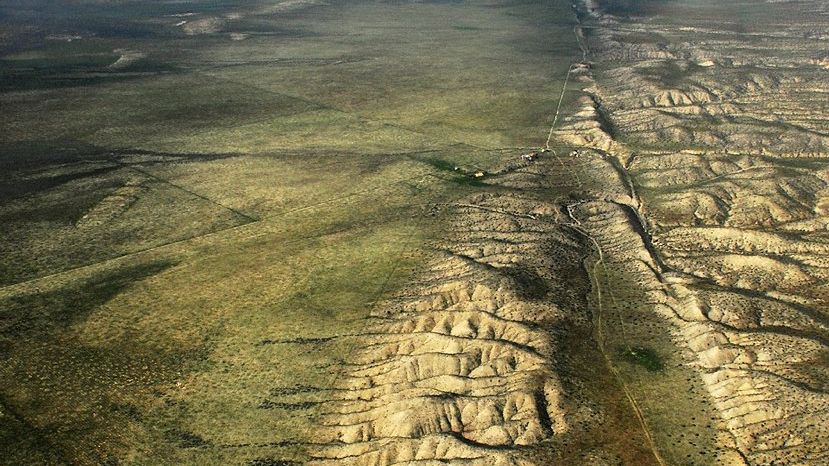
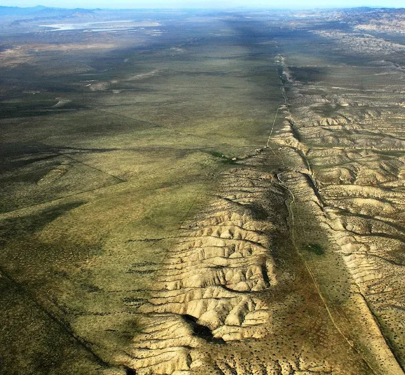
The San Andreas Fault: California’s Most Famous Fracture
The San Andreas Fault extends roughly 750 miles through the state of California, forming part of the tectonic boundary between the Pacific Plate and the North American Plate. It’s a strike-slip fault, meaning the two sides grind past each other horizontally rather than one diving beneath the other. That distinction matters because it concentrates seismic energy along a relatively narrow corridor running straight through some of the most populated land in the country.
More than 30 million people live within 50 miles of the San Andreas Fault, and a magnitude 8 or greater rupture would likely be the costliest natural disaster in U.S. history. The fault crosses the California Aqueduct in multiple places, runs parallel to Interstate 5 through the Tejon Pass, and natural gas pipelines, water mains, fiber-optic trunks, and rail lines all cross the fault, which is why one major scenario projects an estimated 1,600 large fires from ruptured utilities alone.
The risk is currently concentrated on the southern section of the fault, near Los Angeles, because strong earthquakes have occurred relatively recently on the central and northern segments, while the southern section has not seen any similar rupture in at least 300 years. Scientists can’t predict exactly when the next event will occur, but the geological pressure is real, documented, and growing.
The Cascadia Subduction Zone: The Pacific Northwest’s Sleeping Giant
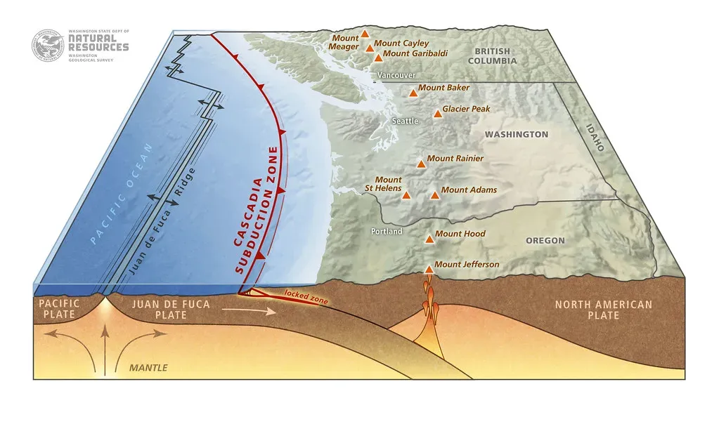
The Cascadia Subduction Zone is a 620-mile-long convergent plate boundary, about 70 to 100 miles off the Pacific coast of North America, stretching from northern Vancouver Island to Northern California, and it is capable of producing magnitude 9 or greater earthquakes and tsunamis that could reach 100 feet high. This is a different kind of threat from the San Andreas. Rather than plates grinding sideways, one plate is slowly diving beneath another, building enormous pressure over centuries.
Scientists have estimated that over the last 10,000 years, more than 40 earthquakes greater than magnitude 8 occurred somewhere along the Cascadia subduction zone, with at least 19 of those around magnitude 9 and rupturing the entire length of the zone. The last known megathrust earthquake occurred in 1700, confirmed both by Japanese tsunami records and Native American oral histories.
Recent FEMA risk assessments project that a full rupture could be the deadliest natural disaster in U.S. history, with the potential for over 10,000 deaths. Cities like Seattle and Portland are now retrofitting bridges and buildings in a race against time. There is an estimated five to seven minutes of shaking along the coastline, with strength and intensity decreasing the further inland you are – leaving coastal residents almost no time to react.
The Hayward Fault: The Most Likely to Strike Next in the Bay Area
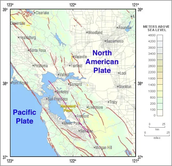
Though only 74 miles long, the Hayward Fault is one of the most dangerous in the United States because it runs directly beneath the East Bay urban corridor of the San Francisco region. Its relatively short length is deceptive. Location is everything in earthquake risk, and this fault threads through some of the most densely built urban infrastructure in California.
More than 2 million people live along or near the Hayward Fault, and infrastructure including BART tunnels, freeways, hospitals, and campuses sits directly atop sections of active ground creep. Sidewalks crack, walls tilt, and curbs slowly offset by inches each decade as the fault shifts even without earthquakes. Its last major quake occurred in 1868, and scientists have called this fault the most likely in the Bay Area to produce a damaging earthquake in the next 30 years.
Seven million Bay Area residents need to be prepared for a major earthquake and weeks of aftershocks, with damages from a Hayward fault rupture alone potentially shaking one million homes, with 77,000 to 152,000 households displaced. The quiet creep of this fault is not relief – it’s a slow countdown.
The New Madrid Seismic Zone: The Midwest’s Hidden Threat
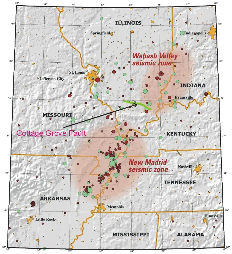
derivative work: Ruslik (talk), Public domain)
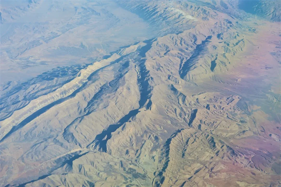
The New Madrid Seismic Zone stretches about 240 miles beneath Missouri, Arkansas, Tennessee, Kentucky, and Illinois, forming one of America’s strangest and most dangerous fault systems. Unlike western faults formed at plate boundaries, New Madrid lies deep within the interior of the continent. Most Americans don’t associate the Midwest with earthquake danger, which is precisely what makes this zone so concerning. The lack of awareness translates directly into a lack of preparedness.
The New Madrid Seismic Zone is best known for a series of four earthquakes in 1811 and 1812, estimated at magnitude 7.5 to 8.0, so strong the Mississippi River reportedly flowed backward. Damage occurred as far away as Washington, D.C., and Charleston, South Carolina. Eyewitnesses reported church bells ringing in Boston and one of the quakes temporarily created Reelfoot Lake in Tennessee as the land subsided dramatically.
If you think you’re safe from earthquakes because you don’t live on the West Coast, think again. One of the most dangerous earthquake zones in the country is right in the heartland, and can trigger quakes felt a thousand miles away. The infrastructure of the central United States, including aging bridges, pipelines, and buildings built with no seismic codes, would face extraordinary strain.
The Wasatch Fault: Utah’s Overdue Reckoning
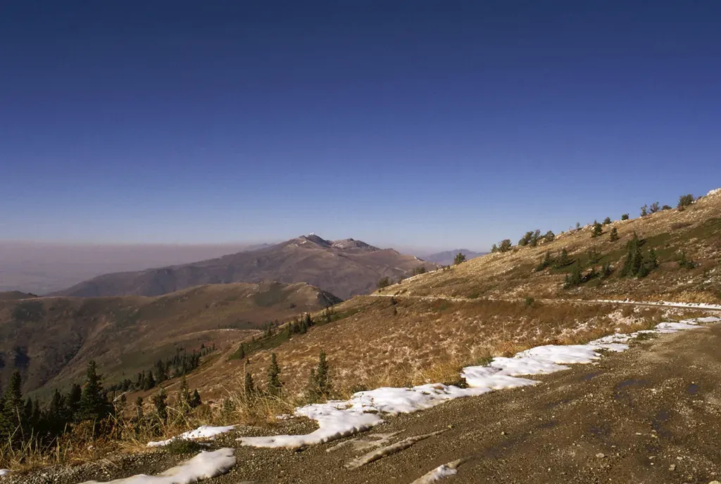
The Wasatch Fault is an active fault located primarily on the western edge of the Wasatch Mountains in Utah and Idaho, about 240 miles long, made up of ten segments, five of which are considered active, with each capable of independently producing earthquakes as powerful as magnitude 7.5. What separates this fault from others is how uniformly its danger is concentrated around populated places rather than remote wilderness.
According to research reports, about 80 percent of Utah’s population lives within 15 miles of the Wasatch Fault, with more than 75 percent of Utah’s economy concentrated in the counties that include the fault. New research shows that although the Wasatch Fault dips sharply at Salt Lake City, it curves more gently at depth, meaning an earthquake rupture could lead to stronger, more intense shaking at the surface than previously expected.
A report from Utah’s Office of Emergency Services predicted that a strong earthquake in Salt Lake City could kill up to 6,200 people, injure 90,000, and cause $40 billion in economic losses. At least 42 percent of buildings along the Wasatch Front are at risk of moderate to severe damage, and many hospitals and schools are located directly atop the fault. The scale of vulnerability here is not hypothetical – it’s structural and deeply embedded in how the region was built.
The Puente Hills Fault: Los Angeles’s Invisible Danger
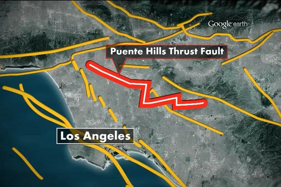
The Puente Hills Fault is an active geological fault located in the Los Angeles Basin in California, discovered in 1999, running about 25 miles in three discrete sections. It is known as a blind thrust fault, meaning the fault plane does not extend to the surface. That invisibility is a significant part of what makes it so threatening. There are no surface scars to warn residents, no visible evidence that anything dangerous lies beneath downtown Los Angeles.
The USGS estimates that if the Puente Hills Fault were to produce a full rupture, damage could top $252 billion, hundreds of thousands of people would be displaced from their homes, and between 3,000 and 18,000 people could die. Geologists have determined that such earthquakes on this fault carry magnitudes of roughly 7.2 to 7.5, with the highest end being about fifteen times stronger than the 1994 Northridge earthquake in terms of energy release.
These faults present an added danger because they are located along the Los Angeles Basin, where local soil conditions are prone to liquefaction – a phenomenon that causes the earth to move like a liquid when shaken. When it occurs beneath vulnerable buildings and structures, the results can be catastrophic. The combination of proximity to millions of people, soil instability, and surface invisibility makes the Puente Hills Fault one of the most alarming scenarios in urban seismology.
What These Fault Lines Have in Common
Fault lines across the United States reveal a restless, dynamic planet beneath our feet. From the iconic San Andreas to the silent depths of Cascadia and the hidden dangers of New Madrid, these massive fractures have shaped coastlines, carved mountains, and influenced cultures. Although quiet most days, each fault holds the potential to remind us suddenly and powerfully that Earth is in constant motion.
The thread connecting all of these zones is the gap between geological reality and public awareness. The faults don’t wait for infrastructure to be upgraded or emergency plans to be finalized. Updated USGS reports show that areas around the Wasatch Front have a greater than 50 percent chance of seeing earthquakes powerful enough to damage buildings over the next century – and similar probabilities apply across the country’s most active zones. The math is patient. The geology is not.
What these fault lines ultimately reveal is that seismic risk in America is not a regional curiosity. It is a national condition, distributed unevenly but never truly absent. Preparedness – whether in building codes, emergency planning, or simply knowing the ground beneath your city – remains the most practical response to forces that science can measure but not yet prevent. The quiet between earthquakes isn’t an absence of danger. It’s just time passing.
- 17 Moments a Horse Chooses You Over the Entire Barn - July 29, 2026
- 13 Signs a Horse Has Handed You Its Whole Heart Without You Realising - July 29, 2026
- 13 Things Vets Notice About Your Dog That They Rarely Say Out Loud - July 29, 2026