
A First Wave of Winter Descends (Image Credits: Images.squarespace-cdn.com)
The eastern United States encountered a sharp shift in weather patterns as an Arctic air mass descended rapidly across the region.
A First Wave of Winter Descends
Forecasters reported that the initial surge of frigid air arrived in the eastern US following a robust cold front. This mass extended southward, reaching as far as Florida by evening. Temperatures plummeted well below seasonal norms, prompting warnings for residents unaccustomed to such chills in southern locales. The National Weather Service highlighted the potential for frost across much of the Southeast, with lows dipping into the 20s in northern Florida areas.
Travel disruptions emerged early, as icy roads formed in higher elevations of the Appalachians. Power demands spiked in urban centers like Atlanta and Charlotte, straining grids amid the sudden demand for heating. Officials urged precautions against hypothermia for outdoor workers and the elderly, emphasizing the rapid onset of these conditions.
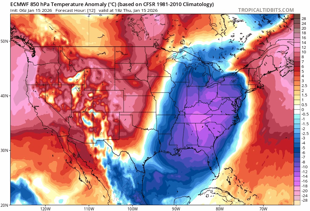
Weekend Storms Stir Snow in Surprising Locations
As the first chill lingered, meteorologists predicted a second Arctic intrusion pushing into the north-central US by early weekend. This system promised to intensify, spreading eastward and triggering low-pressure waves along its boundary. Snowfall became a primary concern, with accumulations expected from Friday night through Saturday in parts of the Midwest and Ohio Valley.
One particularly notable development involved a Sunday low-pressure system that could deliver flurries to southeastern states, including rare wintry mixes in Georgia and northern Florida. Such events marked a departure from typical mild winters in these areas, where snow remains an anomaly. The system’s track suggested possible extensions northward, affecting the corridor from Washington, D.C., to Philadelphia and New York City with light snow or sleet. Transportation authorities prepared for delays, while schools in affected zones considered early closures.
- Northern Florida: Possible trace snow, marking one of the coldest January starts in decades.
- Georgia interiors: Flurries amid gusty winds up to 30 mph.
- Mid-Atlantic cities: Sleet risks leading to slippery sidewalks.
- Ohio Valley: Heavier snow bands, up to 4 inches in isolated spots.
- Great Lakes: Blustery conditions exacerbating lake-effect snow.
Deep Freeze Looms for the Northeast
Following the weekend disturbances, a third Arctic mass positioned itself to dive southward on Sunday night. This influx targeted the northern US initially, then accelerated toward the Mid-Atlantic and Northeast by Monday and Tuesday. Experts from the National Weather Service forecasted temperatures 10 to 20 degrees below average in major cities like Boston and New York.
The prolonged exposure to subzero wind chills raised concerns for infrastructure, including frozen pipes and heightened slip-and-fall incidents. Coastal areas faced additional hazards from nor’easter-like winds, potentially whipping up to 40 mph. Emergency services in the region ramped up readiness, distributing salt supplies and advising on safe heating practices to mitigate carbon monoxide risks.
Broader Impacts and Preparations
The multi-phase cold event stemmed from disruptions in the polar vortex, allowing Arctic air to spill southward more aggressively than usual. According to reports from Newsweek, over 170 million Americans could experience below-average temperatures persisting for weeks. Southern states like Florida saw unusual preparations, with citrus growers deploying protective measures against frost damage to crops.
Energy consumption surged nationwide, with natural gas prices fluctuating in response. Aviation hubs from Chicago to Miami reported flight cancellations, underscoring the event’s reach. Public health officials noted vulnerabilities for at-risk populations, recommending layered clothing and limited outdoor time.
Key Takeaways
- Multiple Arctic surges will dominate eastern US weather through mid-week, with snow risks extending to the Southeast.
- Florida faces rare freezes, impacting agriculture and daily life in the subtropics.
- Northeast residents should prepare for prolonged deep freezes, including potential power outages.
This Arctic invasion serves as a stark reminder of winter’s unpredictable power, even in warmer climes. As communities adapt to these chills, the event underscores the need for robust emergency planning. What steps are you taking to stay warm this week? Share your thoughts in the comments.
As a little kid, I fell in love with nature, wildlife, and animals. Living in the USA, South Africa, Italy, China and Germany gave me the opportunity to discover the world's Wildlife. My favorite animals are Mountain Gorillas, Siberian Tigers, and Great White Sharks.
I'm a certified PADI Open Water Diver, went to Everest Base Camp and Trekked Gorillas in Uganda. I hold a Master of Science in Economics and Finance.
Please send any feedback to feedback@animalsaroundtheglobe.com
- 11 Most Endangered Insects Buzzing in America Today - July 22, 2026
- 10 Most Frequently Googled Animal Birth Facts - July 22, 2026
- 10 Incredible Migration Journeys in the Animal Kingdom - July 22, 2026