Worried about unexpected vet bills?
Pet insurance can cover thousands in unexpected vet costs. Get a free quote from Lemonade in under 2 minutes.
Get My Free Quote →Sponsored · Opens Lemonade.com
In a chilling reminder of nature’s devastating power, one of history’s most destructive volcanoes has reawakened. Mount Pelée, the infamous volcano that completely obliterated the town of Saint-Pierre, Martinique in 1902, killing nearly 30,000 people in minutes, is showing signs of activity once again. This awakening has sparked concern among scientists, local authorities, and residents alike. After lying dormant for decades, recent seismic events and other warning signs have placed the region on alert. The volcano’s history of catastrophic eruption combined with modern monitoring technology creates a complex scenario of risk assessment, emergency preparedness, and the delicate balance between human settlement and natural forces. This article explores the deadly history of Mount Pelée, its current status, and what its reactivation means for the people living in its shadow today.
The Catastrophic 1902 Eruption

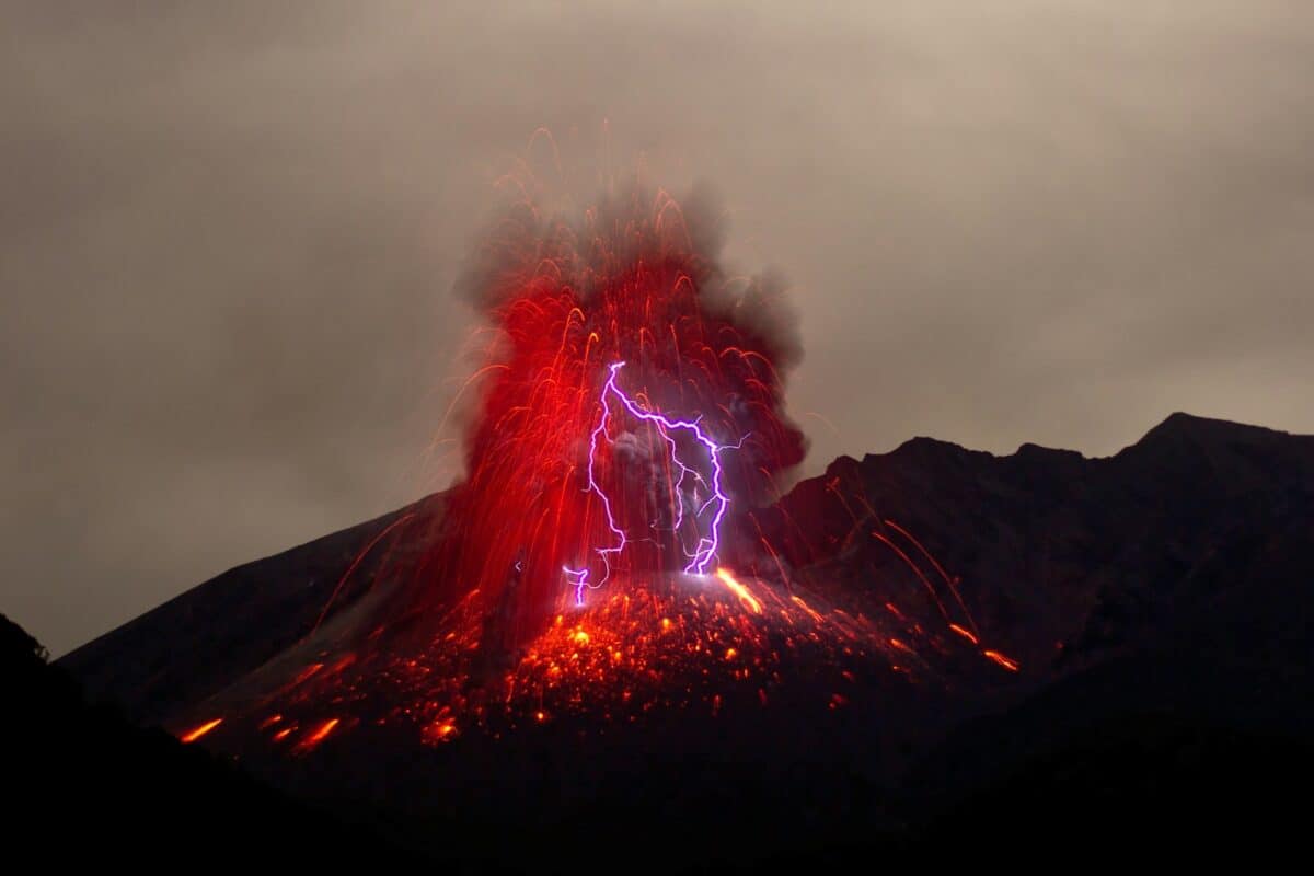
On May 8, 1902, Mount Pelée unleashed one of the deadliest volcanic disasters in recorded history. After weeks of warning signs—including ash falls, sulfurous gases, and the emergence of a lava dome—the volcano erupted with catastrophic force. The primary killer was not lava but a pyroclastic flow—a superheated mixture of gas, ash, and rock moving at hurricane speeds that swept down the mountain’s southern flank.
In under two minutes, this cloud of death engulfed Saint-Pierre, instantly killing an estimated 28,000-30,000 people. The temperature within this flow reached approximately 1,000°C (1,830°F), causing buildings to explode, ships in the harbor to capsize, and most organic matter to instantaneously combust. Only two people in the direct path of destruction survived, including Ludger Sylbaris, a prisoner whose underground cell provided just enough protection from the deadly heat. The eruption essentially erased Saint-Pierre, once known as the “Paris of the Caribbean,” from existence, leaving behind a sobering testament to volcanic power.
The Volcano’s Deadly Legacy

Mount Pelée’s 1902 eruption fundamentally changed our understanding of volcanic hazards and introduced the term “nuée ardente” (glowing cloud) to describe the deadly pyroclastic flows that devastated Saint-Pierre. This event marked a turning point in volcanology, prompting more systematic study of explosive volcanism and its dangers.
Prior to this disaster, many scientists and officials did not fully comprehend the potential for such rapid and complete destruction from a volcano. The aftermath fundamentally altered the region’s development—while Saint-Pierre was eventually rebuilt, it never regained its former prominence as Martinique’s economic and cultural capital.
The eruption has become a pivotal case study in disaster management, demonstrating the catastrophic consequences of underestimating natural hazards and delayed evacuation. It stands as one of the deadliest volcanic disasters of the 20th century, alongside the 1985 Nevado del Ruiz eruption in Colombia and serves as a somber reminder of what Mount Pelée is capable of during periods of activity.
Recent Signs of Awakening
In December 2020, volcanologists detected the first significant signs that Mount Pelée was reawakening from its dormancy. The Martinique Volcano Observatory documented a marked increase in seismic activity beneath the volcano, recording numerous small-magnitude earthquakes occurring at shallow depths of 2-5 kilometers.
This was accompanied by slight but measurable ground deformation detected by GPS stations around the mountain, indicating magma movement below the surface. Scientists also observed changes in the composition of fumarolic gases (volcanic emissions) with increased sulfur dioxide levels—a potential indicator of rising magma. Additionally, thermal anomalies were detected in several areas of the volcanic edifice, particularly around pre-existing fumaroles.
While individually these signals might not raise significant concern, their concurrent appearance prompted authorities to raise the alert level from yellow (vigilance) to orange (heightened vigilance) in certain periods. These phenomena represent the first substantial volcanic unrest at Mount Pelée since its last eruption in 1932, which was considerably less violent than the 1902 catastrophe but still significant.
Understanding Mount Pelée’s Geology
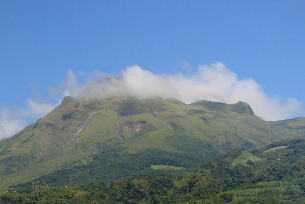
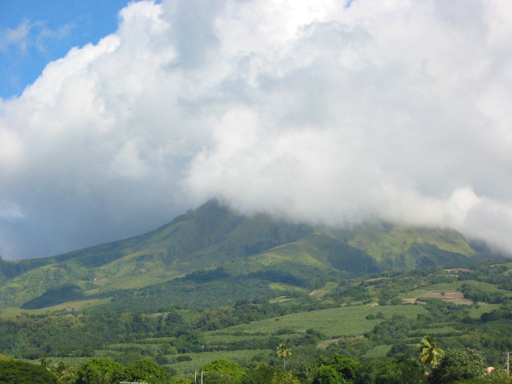
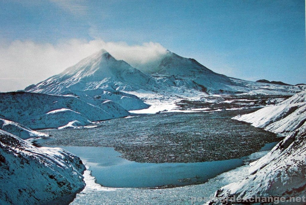
Mount Pelée belongs to the class of volcanoes known as stratovolcanoes or composite volcanoes, characterized by steep profiles and periodic explosive eruptions. It forms part of the Lesser Antilles volcanic arc, which results from the subduction of the North American plate beneath the Caribbean plate.
This specific tectonic setting creates magma with high viscosity and gas content, factors that contribute to Pelée’s explosive nature. The volcano’s historical eruption patterns reveal a cycle of dome-building phases followed by explosive destruction. The mountain stands approximately 1,397 meters (4,583 feet) tall, with a complex summit area featuring multiple craters and domes formed during different eruptive episodes. Geologically, Pelée is relatively young, with its earliest known deposits dating back about 400,000 years.
Its rocks are predominantly andesitic and dacitic in composition—types of magma associated with particularly explosive eruptions. This geological profile helps explain why Mount Pelée produces the devastating pyroclastic flows that made the 1902 eruption so deadly, as the viscous magma traps gases that build pressure until violent release becomes inevitable.
Modern Monitoring Technologies
Unlike in 1902, Mount Pelée is now under constant surveillance using state-of-the-art monitoring technologies. The Martinique Volcano Observatory, established in 1935 and significantly upgraded after being integrated into the Institut de Physique du Globe de Paris, employs a comprehensive multi-parameter monitoring system.
A network of seismometers detects and locates earthquake activity beneath and around the volcano, while tiltmeters and GPS stations measure ground deformation with millimeter-level precision. Gas monitoring instruments analyze changes in the composition and volume of volcanic emissions, particularly tracking sulfur dioxide and carbon dioxide levels that might indicate rising magma. Thermal cameras and satellite-based infrared sensors detect temperature changes across the volcano’s surface.
Groundwater chemistry is regularly sampled for changes that might reflect deeper volcanic processes. This data is collected in real-time and analyzed using sophisticated computer models that help predict potential eruption scenarios. Additionally, LiDAR (Light Detection and Ranging) surveys create detailed topographic maps that assist in modeling potential pyroclastic flow and lahar pathways. This integrated monitoring network provides volcanologists with a much deeper understanding of Mount Pelée’s behavior than was possible during its previous active periods.
Population at Risk Today

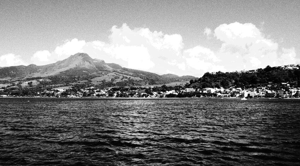
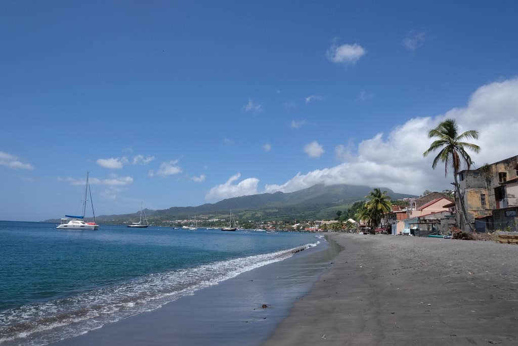
The demographics and settlement patterns around Mount Pelée have changed significantly since 1902, but substantial populations remain at risk. Today, approximately 10,000 people live in Saint-Pierre, which was rebuilt on the ruins of the original city. However, the northern region of Martinique, including communities like Morne-Rouge, Ajoupa-Bouillon, and Le Prêcheur, now houses about 60,000 residents within the potential impact zone of a major eruption.
Unlike in 1902, when Saint-Pierre was the dominant urban center, the island’s population is now more distributed, with Fort-de-France (the capital) located farther south but still potentially vulnerable to ashfall and secondary effects. The island’s total population exceeds 370,000, with tourism bringing thousands of additional visitors yearly. Modern infrastructure creates both advantages and vulnerabilities—improved roads facilitate evacuation but critical facilities like hospitals, power plants, and the airport could be compromised by volcanic activity.
The socioeconomic landscape has evolved with a more service-oriented economy that is less resilient to prolonged disruption than the agricultural focus of 1902. Martinique’s status as an overseas department of France means that substantial international resources would be available for emergency response, but the island’s geography as part of an archipelago presents inherent evacuation challenges.
Current Alert System and Preparedness

Martinique now employs a sophisticated four-level volcanic alert system to manage the risks posed by Mount Pelée. The system ranges from yellow (vigilance), orange (pre-alert), red (alert), to purple (evacuation), with each level triggering specific response protocols. Since the volcano’s reactivation in 2020, authorities have developed comprehensive evacuation plans for communities in high-risk zones, with designated routes, assembly points, and shelter facilities identified.
Regular drills and simulation exercises are conducted to familiarize residents with emergency procedures. Public education campaigns through schools, media, and community workshops have significantly improved volcanic risk awareness among the population. Digital alert systems including SMS notifications, mobile applications, and social media channels complement traditional sirens and radio broadcasts to ensure rapid information dissemination. The French government has allocated substantial resources for emergency preparedness, including specialized equipment and training for first responders.
International coordination protocols are in place with neighboring Caribbean nations and disaster response organizations. Uniquely, Martinique’s preparedness strategy incorporates lessons from both the 1902 disaster and more recent volcanic crises worldwide, creating a multi-layered approach to risk reduction that balances scientific monitoring, public communication, and operational readiness.
Comparing Past and Potential Eruptions

Volcanologists studying Mount Pelée have identified several possible eruption scenarios based on the volcano’s geological record. While the 1902 cataclysm represents the most destructive potential outcome, the mountain has demonstrated varied eruption styles throughout its history. The 1929-1932 eruption was primarily characterized by dome formation and smaller pyroclastic flows, causing limited casualties but significant property damage.
Prehistoric evidence suggests eruption cycles ranging from relatively mild phreatic (steam-driven) explosions to massive plinian eruptions with extensive ashfall and pyroclastic flows. Current activity patterns bear some similarities to the precursory signs observed before both the 1902 and 1929 eruptions, though seismic activity appears more dispersed than the concentrated pattern that preceded the 1902 disaster. Modern modeling suggests that urbanization and land-use changes would alter how pyroclastic flows might travel compared to historical events.
Depending on the eruption’s nature, potential impacts range from localized disruption to regional catastrophe affecting not just Martinique but potentially neighboring islands through ashfall and tsunamis. Scientists emphasize that while the volcano’s reactivation is concerning, the current monitoring capabilities provide a crucial advantage over previous generations, allowing for earlier detection of escalating danger signs and potentially more timely evacuation measures.
Cultural and Psychological Impact

The reawakening of Mount Pelée carries profound psychological weight for Martinique’s population, particularly in the northern communities living in the volcano’s shadow. The 1902 disaster remains deeply embedded in the island’s collective memory and cultural identity, transmitted through generations via oral histories, literature, and commemorative events. For many families, the current volcanic activity has reactivated ancestral trauma and anxiety, particularly among older residents who heard firsthand accounts from survivors.
Local artists, writers, and musicians have responded to the volcano’s renewed activity through creative expressions that process community fears while celebrating the island’s resilience. Religious and spiritual perspectives also shape responses, with some communities incorporating traditional Creole spiritual practices alongside Catholic observances in relation to the volcanic threat. Mental health professionals report increased stress-related symptoms in communities closest to the volcano, prompting specialized psychological support programs.
Interestingly, tourism has seen a complex response—while some visitors avoid the area due to perceived danger, others are specifically drawn by what’s called “disaster tourism” or scientific interest. Cultural heritage concerns have emerged as well, with efforts to document and protect historical sites that might be threatened by future eruption, particularly the ruins and artifacts from the 1902 catastrophe that hold significant historical value.
Economic Implications of Volcanic Activity

The volcano’s reactivation has triggered multi-faceted economic consequences for Martinique. Insurance premiums have increased substantially for properties in high-risk zones, creating financial pressure for homeowners and businesses. The real estate market has experienced notable shifts, with property values decreasing in areas closest to Mount Pelée while rising in southern regions perceived as safer.
Tourism, which accounts for approximately 7% of Martinique’s GDP, has seen segment-specific impacts—conventional leisure tourism has declined in northern areas while scientific tourism and educational visits focused on the volcano have increased. Agricultural operations face significant vulnerability, particularly the region’s banana plantations and rum distilleries that represent key export industries. Infrastructure investment has been redirected toward resilience projects, including improved roads for potential evacuation and reinforced public buildings. The uncertainty surrounding the volcano’s activity has complicated long-term economic planning, with some major development projects placed on hold pending clearer risk assessments. French national funding has increased for both monitoring activities and economic support programs for affected businesses.
Some innovative enterprises have emerged in response, including specialized geological tour companies and volcanic risk consulting services. The fishing industry faces potential disruption should volcanic activity affect marine ecosystems or port infrastructure. Overall, economists estimate that sustained volcanic unrest without a major eruption could reduce Martinique’s annual economic growth by 0.5-1.5%, while a significant eruption would have much more profound economic implications.
Scientific Research Opportunities
Mount Pelée’s reactivation has created a significant scientific opportunity, drawing researchers from around the world to study this historically important volcano. Geophysicists are deploying new-generation monitoring equipment including drone-based gas sampling systems and advanced satellite interferometry to track ground deformation with unprecedented precision.
Petrologists are analyzing recently collected samples from fumaroles to better understand the magmatic system’s current state and composition. Computer scientists are developing improved AI algorithms that can process the massive data streams from monitoring networks to identify subtle patterns that might precede eruptive events. The volcano serves as a natural laboratory for testing emerging theories about magma movement and eruption triggering mechanisms. International research collaborations have intensified, with scientists from the United States Geological Survey, Japanese Meteorological Agency, and European volcanological institutes partnering with French researchers. Social scientists are documenting risk perception and community response patterns, providing valuable data for disaster preparedness in volcanic regions worldwide.
Climate scientists are monitoring local atmospheric conditions, as any significant eruption could have temporary regional climate effects. Marine biologists are establishing baseline ocean ecosystem data to track potential impacts of volcanic materials on marine environments. This concentrated research effort not only enhances understanding of Mount Pelée specifically but contributes to advancing volcanology more broadly, potentially improving eruption forecasting capabilities for similar volcanoes globally.
The Global Context of Volcanic Monitoring
Mount Pelée’s current activity occurs within a broader global context of volcanic monitoring and disaster risk reduction. Worldwide, approximately 1,350 potentially active volcanoes exist, with about 50-70 erupting in any given year. The techniques and technologies being applied at Pelée reflect significant advances in the international volcanological community since major disasters like the 1980 Mount St. Helens eruption and the 1991 Mount Pinatubo event.
Global coordination occurs through organizations like the World Organization of Volcano Observatories (WOVO) and the International Association of Volcanology and Chemistry of the Earth’s Interior (IAVCEI), which facilitate information sharing and standardized approaches. Satellite monitoring now provides consistent coverage of even remote volcanoes, with programs like NASA’s Earth Observatory regularly tracking thermal anomalies and gas emissions worldwide. The integration of social media and crowdsourcing has created new channels for public reporting of volcanic phenomena, supplementing traditional scientific observation. Economic disparities in monitoring capabilities remain significant—while Martinique benefits from French resources, many high-risk volcanoes in developing nations lack comprehensive monitoring systems.
Climate change considerations have entered volcanic risk assessment, as changing precipitation patterns may affect hydrothermal systems and landslide potential on volcanic edifices. Mount Pelée’s monitoring program represents one of the more sophisticated systems globally, though it builds upon lessons learned from volcano observatories around the world, particularly from comparable island arc volcanoes in places like Japan, Indonesia, and the Philippines.
Conclusion: Living in the Shadow of Uncertainty

The reawakening of Mount Pelée presents a profound reminder of humanity’s complex relationship with geological forces beyond our control. While the volcano’s current activity does not necessarily presage an imminent catastrophic eruption like that of 1902, it demands sustained vigilance, scientific monitoring, and community preparation. The stark contrast between today’s sophisticated monitoring networks and the limited scientific understanding that preceded the Saint-Pierre disaster reflects how far volcanology has advanced, yet uncertainty remains an inevitable aspect of volcanic forecasting.
For Martinique’s residents, this uncertainty requires balancing pragmatic preparedness with the continuation of daily life—a psychological and practical challenge that communities near active volcanoes worldwide understand intimately. As climate change potentially influences volcanic systems and growing populations increase vulnerability to natural hazards, Mount Pelée’s current activity offers important lessons about resilience, risk communication, and the critical importance of integrating scientific expertise with community engagement. Whatever the ultimate outcome of this reawakening, it has already succeeded in ensuring that the lessons from one of history’s deadl
Worried about unexpected vet bills?
Pet insurance can cover thousands in unexpected vet costs. Get a free quote from Lemonade in under 2 minutes.
Get My Free Quote →Sponsored · Opens Lemonade.com
From exploring the marine wonders in the Azores and witnessing the vast savannas of Kenya, to delving deep into the rich biodiversity of South Africa and traversing iconic landscapes in Australia and the US like Yellowstone, Chris's experiences are vast.
With a penchant for diving alongside sharks, the ocean holds a special place in his heart.
Through his academic insights, he champions wildlife conservation, striving with 'Animals Around The Globe' to cultivate a profound connection between humans and animals, enhancing our mutual appreciation.
Connect with him at Feedback@animalsaroundtheglobe.com.
- The Most Common Backyard Wildlife in Pennsylvania - June 9, 2026
- The Surprising Way Sea Otters Use Rocks as Tools - June 9, 2026
- Squirrels Adopt Orphaned Babies Like Their Own - June 9, 2026