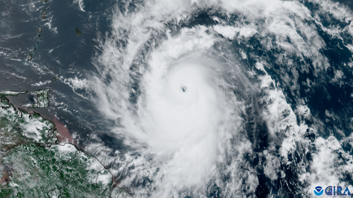
The ocean is speaking, and its message isn’t comforting. Over the past few decades, something dramatic has been shifting beneath the surface of our seas, and the consequences are playing out in spectacular and terrifying fashion along our coastlines. Picture this: a storm that was merely Category 2 strength yesterday now barrels toward land as a monstrous Category 5 behemoth, leaving communities scrambling with hours instead of days to prepare. This isn’t science fiction. This is the new reality of hurricane behavior in 2026.
Global sea surface temperatures have increased approximately 2.8°F since the beginning of the 20th century, and ocean heatwaves – large areas of above-normal temperatures that can last for months – are much more common and widespread. The question on everyone’s mind isn’t whether hurricanes are changing. They absolutely are. The real question is whether our entire classification system, our understanding of these storms, and our preparedness strategies can keep pace with what the warming ocean is creating.
The Hidden Fuel Tank Beneath the Waves
Here’s the thing most people don’t realize about hurricanes: they’re basically heat engines, and the ocean is their fuel source. The North Atlantic and the Western Pacific are changing in a crucial way because the heat now runs deep, stacking warm water hundreds of feet below the surface. Think of it like this: imagine filling your car’s tank versus connecting it to an underground reservoir. That’s essentially what’s happening.
As a storm churns, it stirs cooler water up from below, which often knocks the intensity down, but hot spots short-circuit that self-limiter because when heat extends unusually deep, a storm can roar across the ocean and keep pulling energy from warm layers top to bottom. Both natural temperature cycles and long-term warming contribute to these deep warm-water regions, but human-caused climate change is responsible for roughly 60-70% of the growth of these hot spots. The implications are staggering.
Rapid Intensification: The Nightmare Scenario

Let’s be real, forecasters have struggled with rapid intensification for years. About 80% of major hurricanes undergo rapid intensification, defined as an increase in the maximum sustained winds of a tropical cyclone of at least 30 knots in a 24-hour period. That’s roughly a jump of 35 mph overnight.
Within 240 miles of coastlines, rapidly intensifying storms are now significantly more common than they were 40 years ago, with Hurricane Michael in 2018 leaping from a Category 2 storm to Category 5 the day before making landfall in the Florida panhandle, claiming dozens of lives and causing $25 billion in damage. The likelihood of a tropical cyclone with hurricane-force winds undergoing rapid intensification has increased from 1 percent in the 1980s to 5 percent, with statistically significant increases in the frequency of tropical cyclones undergoing multiple episodes of rapid intensification observed since the 1980s. When a storm explodes in strength just before landfall, evacuation plans crafted for a moderate storm become dangerously inadequate.
Are We Witnessing the Birth of Category 6 Hurricanes

For over five decades, Category 5 has been the ceiling. Climate scientists have introduced a hypothetical Category 6 to the Saffir-Simpson Wind Scale, which would encompass storms with wind speeds greater than 192 mph. This isn’t just academic hair-splitting.
When researchers performed a historical data analysis of hurricanes from 1980 to 2021, they found five storms that would have been classified as Category 6, and all of them occurred in the last nine years of record. Hurricane Patricia holds the record as the strongest tropical cyclone ever observed, with winds reaching up to 185 knots, powerful enough to qualify as a Category 7 storm, if such a category existed. Honestly, when you have storms breaking the theoretical upper limits of your measurement system, it’s a sign something fundamental has shifted. The idea isn’t to scare people, but to accurately communicate the risk we’re facing.
Warmer Waters, Stronger Winds: The Direct Connection
The relationship between ocean temperature and hurricane intensity isn’t subtle. A one degree Fahrenheit rise in ocean temperature can increase a hurricane’s wind speed by 15 to 20 miles per hour, enough to shift a storm to the next category of severity. Let that sink in for a moment.
Climate change caused the maximum wind speeds generated by roughly 80% of Atlantic Basin hurricanes from 2019 and 2023 to intensify by an average of 18 miles per hour, with thirty hurricanes out of 38 in the study reaching intensities roughly one category higher on the Saffir-Simpson Hurricane Wind Scale compared to their expected strength in an environment without influence of human-caused climate change. NOAA predicts an increase in Category 4 and 5 hurricanes, alongside increased hurricane wind speeds, with warmer sea temperatures also causing wetter hurricanes, with 10-15 percent more precipitation from storms projected. More wind and more water means exponentially more destruction when these systems make landfall.
The Expanding Hot Spot Zones

Not all ocean areas are created equal when it comes to hurricane fuel. Nearly all Category-6-caliber storms form within distinct oceanic hot spots, with the largest sitting in the Western Pacific, east of the Philippines and Borneo, and another hot spot spanning a broad swath of the North Atlantic near and east of Cuba, Hispaniola, and Florida.
What’s concerning is that these zones aren’t static. Researchers now see evidence that both regions have expanded, with the Atlantic hot spot pushing west into much of the Gulf of Mexico and east beyond northern South America, while in the Western Pacific, the warm reservoir covers more area than it used to. Population and infrastructure have surged along many of the same coastlines that sit downrange of these expanding hot spots, creating a dangerous overlap where warm water extends so deep that storms do not cool as easily. It’s hard to say for sure, but the convergence of more people and more intense storm zones could create unprecedented disaster scenarios in coming decades.
What Climate Models Tell Us About the Future

Peering into the future is always uncertain, but climate models offer sobering projections. With two degrees Celsius of global warming above pre-industrial levels, the risk of Category 6 storms increases by up to 50% near the Philippines and doubles in the Gulf of Mexico. We’re not talking about some distant timeline either.
While most models show either no change or a decrease in hurricane frequency in a warmer climate, a greater proportion of the storms that form will reach very intense levels, meaning while there may be fewer storms, the ones that form have a greater chance of becoming stronger. Models estimate that human-caused global warming has increased hurricane extreme hourly rainfall rates by 11%. The pattern is becoming clear: quality over quantity, unfortunately in the worst possible way. Fewer total storms but dramatically more powerful ones concentrating damage in shorter, more devastating bursts.
Beyond Wind Speed: The Water Threat
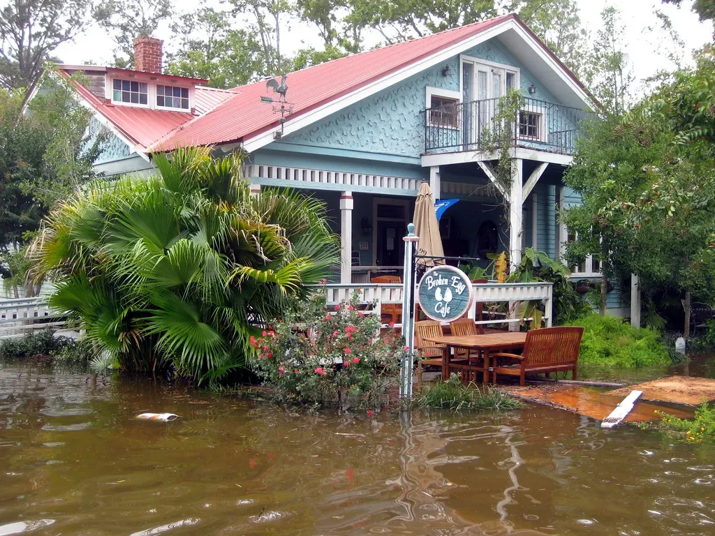
Wind gets all the headlines, but water kills more people during hurricanes than any other factor. Sea level rise is triggered by human-caused global warming as land ice melts and warmer ocean water expands, with the average global sea level having already risen by well over half a foot since 1880, about four of those inches since 1993.
Meanwhile, hurricanes are traveling more slowly, making more damage possible because slow-moving storms bring a higher risk of flooding as more rain is dumped over a particular area before a storm moves on. When a hurricane makes landfall, water is pushed inland by high-speed winds in an event known as storm surge, with every additional inch of sea level rise allowing the surge to travel farther inland, threatening a wider area and causing more damage, death, and injury. Combine slower storms, higher sea levels, and more intense rainfall, and you’ve created a flooding nightmare that makes older disaster plans obsolete. The financial toll alone is staggering, but the human cost is incalculable.
Preparing for an Uncertain Future

So where does this leave us? The scientific evidence is overwhelming that rising ocean temperatures are fundamentally altering hurricane behavior. Storms powerful enough to exceed Category 5 are appearing more often, with over half occurring in just the past decade, leading researchers to say recognizing a new Category 6 could improve public awareness and disaster planning. Whether or not we officially adopt a sixth category, the reality of these super-charged storms isn’t going away.
The oceans have absorbed massive amounts of heat over the past century, and that energy has to go somewhere. When it fuels hurricanes, the results are catastrophic in ways we’re only beginning to fully understand. Communities in hurricane-prone regions face tough choices about infrastructure, building codes, and even whether certain coastal areas remain viable for human habitation long-term.
Climate change isn’t a future problem anymore. It’s reshaping our present, one unprecedented storm at a time. The question isn’t whether rising ocean temperatures can . They already have, and they will continue to do so with increasing frequency and ferocity unless we dramatically alter our trajectory. What will you do differently the next time a hurricane approaches your region?