In the shadow of Mount St. Helens stands a lesser-known but equally formidable titan: Mount Rainier. While most Americans remember the catastrophic eruption of Mount St. Helens in 1980, fewer are familiar with the devastating lahar (volcanic mudflow) that descended from Mount Rainier approximately 500 years ago, completely obliterating a settlement that would later become the town of Orting, Washington. This geological event, known as the Electron Mudflow, serves as a stark reminder of nature’s volatile power and the potential dangers that still lurk beneath one of America’s most picturesque landscapes. As we explore this forgotten disaster, we’ll discover how a sleeping giant reshaped the Puyallup River Valley and why modern-day residents live with both the beauty and peril of their volcanic neighbor.
The Sleeping Giant: Mount Rainier’s Volcanic History
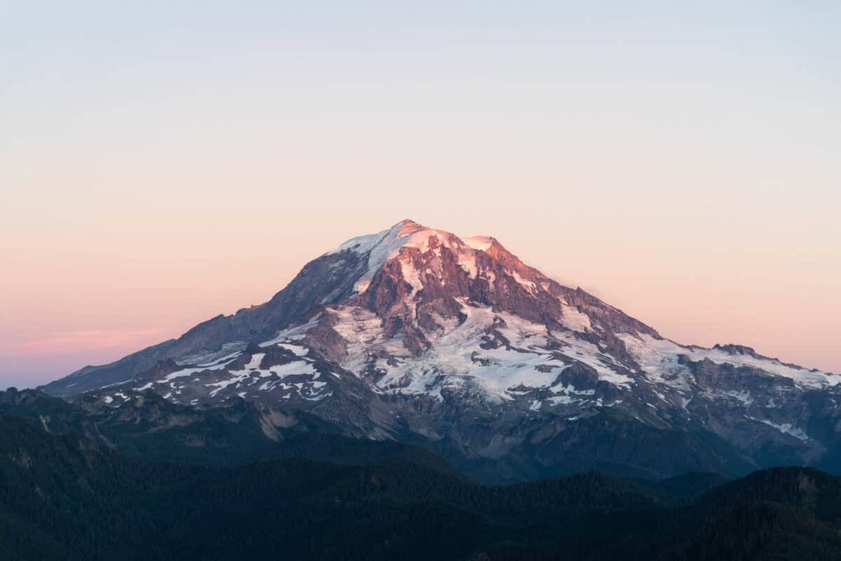
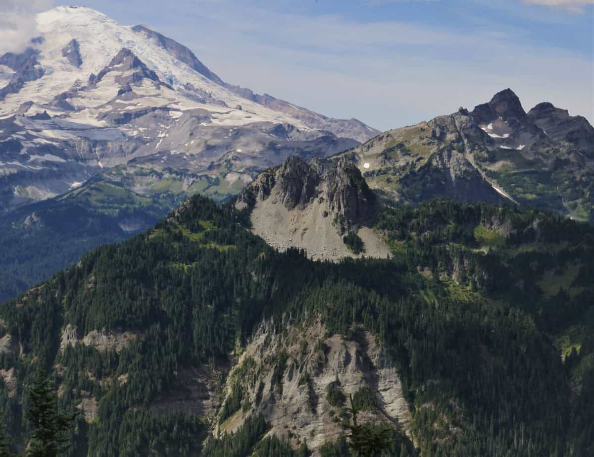
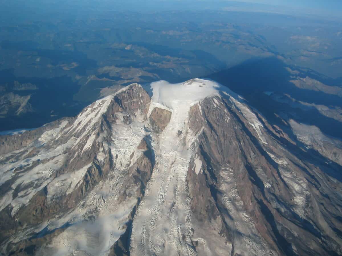
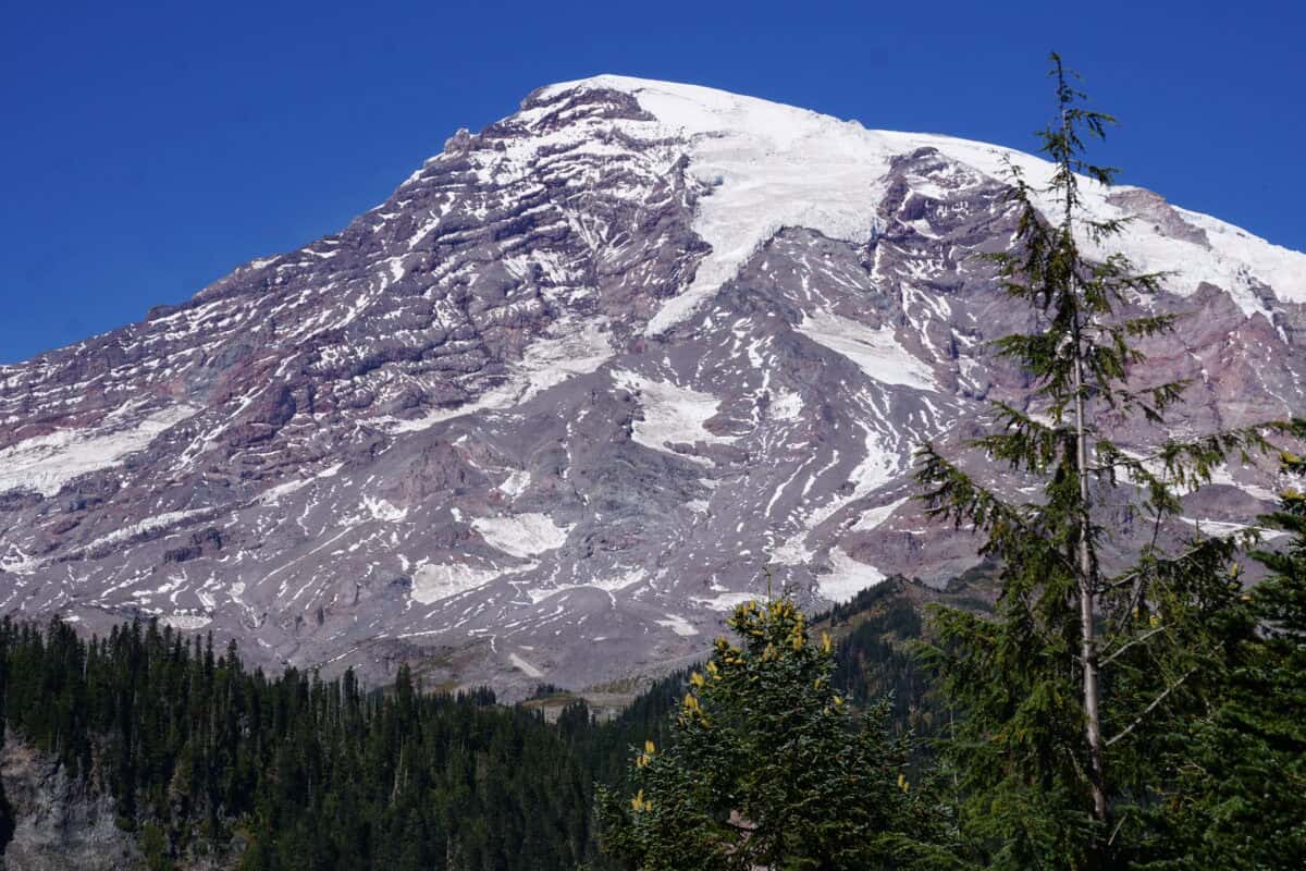
Towering at 14,411 feet, Mount Rainier isn’t just Washington state’s highest peak—it’s an active stratovolcano with a complex eruptive history spanning over half a million years. Located about 60 miles southeast of Seattle in the Cascade Range, this massive volcano has produced numerous lahars, pyroclastic flows, and ash clouds throughout its geological lifetime. Scientists classify Mount Rainier as an “episodically active” volcano, having last erupted in the 1840s, though smaller steam explosions have occurred as recently as the late 19th century.
Unlike the explosive Mount St. Helens, Rainier’s primary threat comes not from its eruptions directly, but from the massive lahars that can be triggered by volcanic activity melting the mountain’s substantial glaciers. With more than 25 named glaciers covering approximately 35 square miles of its surface, Mount Rainier contains more ice than all other Cascade volcanoes combined—creating perfect conditions for devastating mudflows when volcanic heat meets frozen water.
The Electron Mudflow: A Town Vanishes

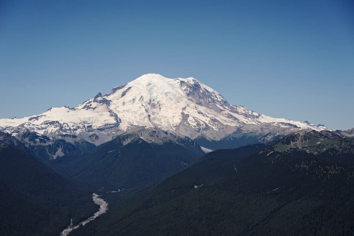
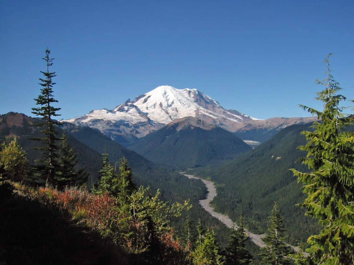
Approximately 500 years ago, a section of Mount Rainier’s western flank catastrophically collapsed, creating what geologists now call the Electron Mudflow. Without warning, this enormous mass of water-saturated rock, soil, and volcanic material thundered down the mountainside at speeds up to 45 miles per hour. The resulting lahar traveled over 30 miles along the Puyallup River valley, burying everything in its path under layers of mud and debris up to 20 feet thick.
Archaeological and geological evidence suggests that numerous indigenous settlements existed in the path of this devastating flow, including sites in the area that would later become the town of Orting. These communities were completely obliterated, with no warning and little chance of escape. The Electron Mudflow earned its name from the small community of Electron, where the mudflow deposits were first scientifically documented, though its reach extended much further down the valley. Today, subtle variations in soil composition and elevation throughout the Puyallup Valley bear witness to this catastrophic event that once scoured the landscape clean.
Indigenous Knowledge and Oral Histories
Long before geologists studied the Electron Mudflow, indigenous peoples of the Pacific Northwest preserved knowledge of Mount Rainier’s destructive potential through oral traditions. The Puyallup, Nisqually, and other Coast Salish tribes who inhabited the valleys surrounding the mountain for thousands of years passed down stories of the “mountain that was angry” and “rivers filled with earth.” Tribal elders recounted tales of catastrophic floods of mud that destroyed villages and forced relocations.
These oral histories, once dismissed by early Western scientists, have proven remarkably consistent with modern geological findings about the timing and scale of major lahars. Indigenous names for Mount Rainier, including “Tahoma” and “Tacoma” (meaning “mother of waters” or “snow mountain” in various local languages), reflect both reverence for the mountain and acknowledgment of its power. The destruction of indigenous settlements by the Electron Mudflow represents not just a geological event but also a significant cultural disruption for the region’s original inhabitants, whose descendants continue to maintain spiritual and cultural connections to the mountain despite its destructive history.
What Causes Deadly Lahars?
Lahars represent one of the most dangerous volcanic hazards, especially for a volcano with Mount Rainier’s extensive glacial coverage. These volcanic mudflows form when hot volcanic material rapidly melts snow and ice, creating a slurry of water, rock, soil, and volcanic debris that can flow long distances down river valleys. Unlike ordinary floods, lahars have the consistency of wet concrete and can carry massive boulders, trees, and even buildings within their flow. The unique danger of lahars stems from their trigger mechanisms—they don’t always require an eruption.
While some lahars form during active eruptions, others can be initiated by minor seismic activity, heavy rainfall, or spontaneous collapse of hydrothermally altered (chemically weakened) sections of the volcano. The Electron Mudflow likely resulted from such a collapse rather than a major eruption, making it particularly treacherous as it provided little warning.
With a density approximately twice that of water and tremendous momentum, lahars can travel great distances along river valleys, easily overtopping riverbanks and destroying infrastructure. What makes Mount Rainier’s lahar potential particularly concerning is the combination of its extensive glacial coverage, its history of flank collapses, and the large population centers that have developed along the river valleys radiating from the mountain.
Orting: Living in the Shadow of Danger

Modern-day Orting, Washington sits directly atop the deposits of the Electron Mudflow that once obliterated earlier settlements in this same location. With a population of approximately 8,000 residents, this picturesque town exists in what geologists soberly refer to as a “lahar inundation zone.” If a similar mudflow were to occur today, the entire town could be buried under mud and debris with potentially catastrophic loss of life. Residents of Orting live with this geological sword of Damocles hanging over them, though many go about their daily lives with minimal concern about the threat.
Local schools conduct regular lahar evacuation drills, teaching children to move quickly to higher ground at the sound of warning sirens. The town has established designated evacuation routes leading to safety, though experts acknowledge that even with modern monitoring systems, residents might have as little as 30-40 minutes between a lahar’s formation and its arrival in Orting. What makes Orting’s situation particularly precarious is its geography—nestled between the Carbon and Puyallup Rivers in a valley with limited high ground access points. Despite the risk, the town continues to grow, with new housing developments expanding into areas that geological evidence suggests have been repeatedly inundated by lahars throughout the mountain’s history.
Monitoring the Mountain: Early Warning Systems
Following the sobering lessons of Mount St. Helens, scientists have established comprehensive monitoring systems around Mount Rainier. The USGS Cascades Volcano Observatory maintains an array of seismometers, GPS stations, gas monitoring equipment, and stream gauges to detect early signs of volcanic activity or lahar formation. Perhaps most important for communities like Orting are the lahar detection systems installed along key drainage routes from the mountain.
These systems use acoustic flow monitors (AFMs) that can detect ground vibrations caused by an approaching lahar, automatically triggering warning sirens in downstream communities. Complementing these automated systems, the Pierce County Department of Emergency Management has installed one of the nation’s most advanced lahar warning networks, with multiple redundant components to ensure functionality even if some systems fail during an emergency.
For Orting residents, these monitoring networks might provide the critical minutes needed to reach higher ground before a lahar arrives. However, scientists acknowledge the limitations of these systems—particularly small lahars or those triggered by spontaneous flank collapses might provide minimal warning time. Despite these technological advances, the most effective protection remains public education and preparedness, with regular drills ensuring that valley residents know exactly what to do when warning sirens sound.
Beyond Orting: Other Communities at Risk

While Orting faces perhaps the most immediate threat from Mount Rainier lahars, it’s far from the only community at risk. The towns of Puyallup, Sumner, Fife, and parts of Tacoma all sit atop ancient lahar deposits, evidence of the mountain’s repeated impact on the region. These communities, with a combined population exceeding 150,000 residents, have developed in valleys carved and filled by previous lahars over thousands of years.
The Port of Tacoma, a major economic hub for the Pacific Northwest, also sits within the potential inundation zone of a catastrophic lahar. Even more concerning to emergency planners is that Interstate 5, the main north-south transportation artery for the western United States, crosses directly through lahar-prone valleys. A major lahar could potentially sever this critical infrastructure link, complicating regional recovery efforts. Unlike Orting, which has established clear evacuation routes to nearby high ground, some of these communities face more challenging evacuation scenarios due to their size, population density, and distance from safe zones.
Emergency management officials continue to refine evacuation plans, though they acknowledge that a large lahar during peak traffic hours could create unprecedented challenges. The economic impact of such an event would extend far beyond the immediate destruction, potentially affecting regional and national supply chains, transportation networks, and commerce.
The Osceola Mudflow: An Even Greater Catastrophe
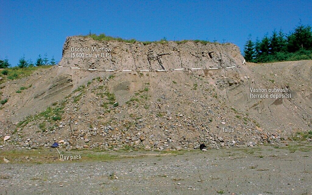
As massive as the Electron Mudflow was, it pales in comparison to an even larger lahar that descended from Mount Rainier approximately 5,600 years ago. The Osceola Mudflow, triggered by a major collapse of the volcano’s northeast flank, released over 0.7 cubic miles of material—enough to fill a million Olympic swimming pools.
This colossal lahar traveled over 45 miles down the White River valley, eventually reaching Puget Sound and changing the coastline near present-day Auburn and Kent. At its deepest points, the Osceola deposits reached 75 feet thick, completely transforming the topography of the White River valley. Geological evidence suggests the collapse may have been preceded by volcanic activity that chemically weakened the mountain’s structure through hydrothermal alteration. The scale of the Osceola Mudflow demonstrates Mount Rainier’s capacity for catastrophic events that dwarf anything in recorded history.
Modern cities like Enumclaw, Auburn, and Kent now occupy land that was once scoured clean by this enormous mudflow. While an event of Osceola’s magnitude represents a low-probability scenario, it remains within the realm of geological possibility, representing what emergency planners term a “low-frequency, high-consequence” hazard. The existence of multiple massive prehistoric lahars confirms that the Electron Mudflow wasn’t an isolated incident but part of a recurring pattern in Mount Rainier’s geological behavior.
Mount Rainier National Park: Beauty and Danger
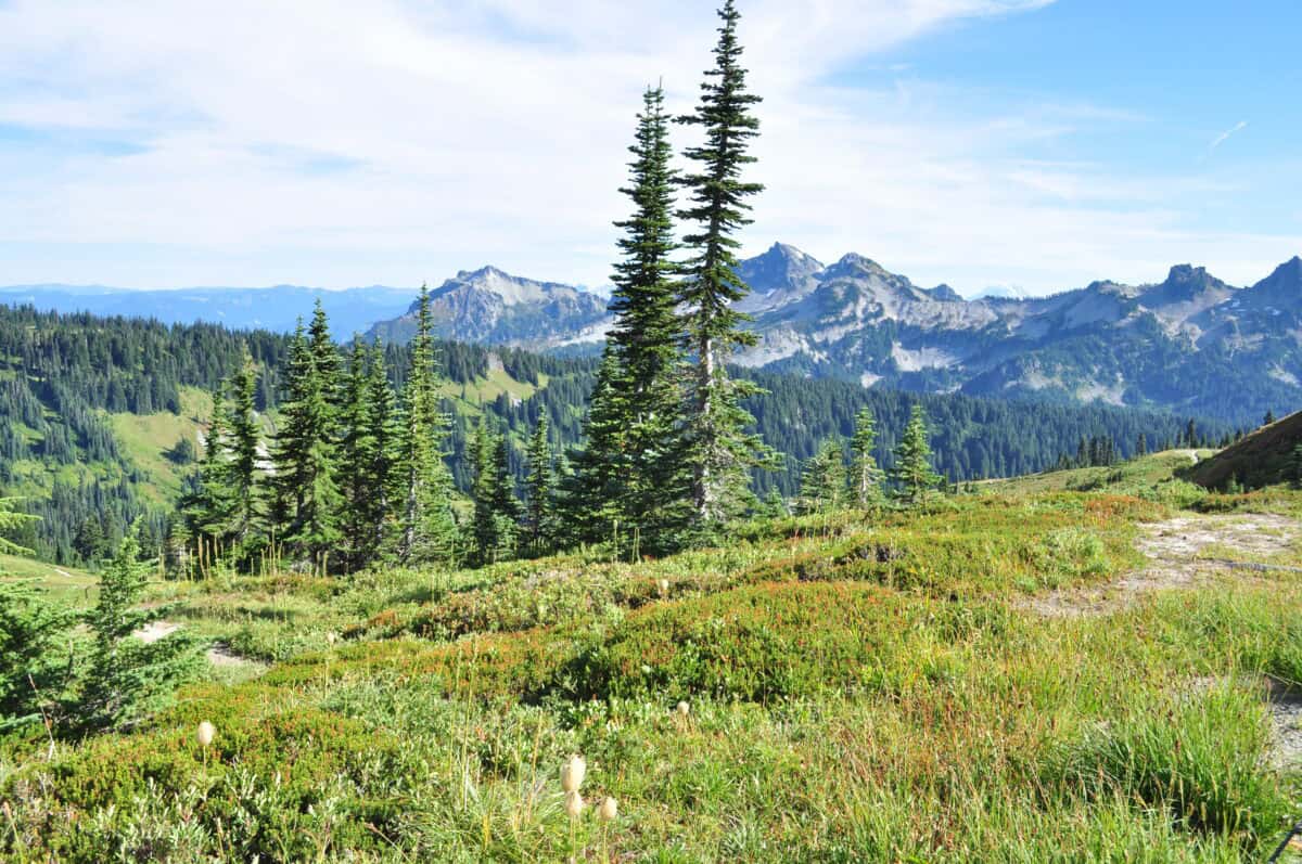
Established in 1899, Mount Rainier National Park draws over two million visitors annually to experience the volcano’s spectacular alpine scenery, wildflower meadows, and ancient forests. While visitors marvel at the mountain’s beauty, few fully comprehend its potential dangers. The Paradise visitor area, one of the park’s most popular destinations, sits atop ancient lahar deposits from previous volcanic events. Park rangers provide education about volcanic hazards, though the emphasis understandably tends toward more immediate risks like hypothermia, avalanches, and navigational challenges rather than volcanic eruptions or lahars.
The National Park Service has established evacuation protocols for various volcanic scenarios, but the remote nature of much of the park presents unique challenges for emergency response. Climbers attempting to summit Mount Rainier (approximately 10,000 annually try, with about half succeeding) face additional risks from sudden changes in volcanic activity. Despite these dangers, the park represents an invaluable resource for scientific research, allowing geologists to study past eruptive behavior and better understand potential future scenarios. The contrast between the mountain’s serene beauty and its volatile potential embodies the complex relationship between humans and the powerful geological forces that shape our landscape—forces that transformed a thriving settlement into the buried foundation upon which Orting was later built.
Future Eruptions: Not If, But When
Volcanologists monitoring Mount Rainier don’t frame the discussion in terms of if the volcano will erupt again, but when. Based on its eruptive history, Mount Rainier displays an eruption pattern averaging about one event every 500-1,000 years, with its last confirmed eruption occurring in the 1840s. While this might suggest we’re not “due” for an eruption, volcanic systems don’t operate on predictable timetables.
The mountain continues to exhibit signs of an active volcanic system, including occasional small earthquake swarms, thermal features, and gas emissions from the summit crater. Scientists from the USGS rank Mount Rainier as a “very high threat” volcano based on its eruptive potential and proximity to populated areas. What particularly concerns geologists isn’t necessarily a massive explosive eruption like Mount St. Helens in 1980, but rather how even a relatively small eruption could trigger catastrophic lahars by melting portions of the mountain’s extensive glaciers.
Climate change adds another variable to this complex equation—warming temperatures are already causing glacial retreat, potentially altering the mountain’s stability and hydrology in ways that might affect future volcanic behavior. While modern monitoring systems would likely detect precursory signs before a major eruption, the mountain’s history of spontaneous flank collapses producing lahars without eruptions represents a scenario that might offer minimal warning.
Living with Volcanic Risk: A Cultural Perspective

The story of Orting and Mount Rainier offers a fascinating case study in how humans perceive and adapt to low-probability, high-consequence natural hazards. Despite clear geological evidence of past catastrophes and scientific consensus about future risks, people continue to build homes, businesses, and lives in lahar inundation zones.
This apparent contradiction reflects complex psychological, economic, and cultural factors that influence risk perception. For many residents, the daily visual presence of Mount Rainier becomes normalized over time—the mountain transitions from a potential threat to simply part of the landscape. Property values in lahar zones tend to be lower than comparable areas outside risk zones, creating economic incentives that often outweigh hazard considerations for homebuyers. Local governments face difficult balancing acts between public safety, property rights, development pressures, and tax revenue needs.
Some communities have implemented stricter building codes and zoning regulations in response to lahar risks, though these measures address building survivability rather than human safety during an actual event. Public education efforts continually battle what emergency management professionals call “hazard amnesia”—the tendency for awareness and concern to fade as time passes since the last disaster. The situation parallels other communities worldwide that exist in the shadow of active volcanoes, from Naples near Mount Vesuvius to Japanese towns near Mount Fuji, reflecting humanity’s persistent tendency to prioritize immediate benefits over low-probability (but potentially catastrophic) future risks.
Conclusion: The Mountain’s Message
The forgotten volcano that erased a town in Washington continues to stand as both sentinel and warning to those who live in its shadow. Mount Rainier’s deadly Electron Mudflow, which obliterated early settlements in what would become Orting, represents not just a historical footnote but a preview of a geological event that will almost certainly recur in the future. As modern communities expand across ancient lahar fields, the volcano’s message becomes increasingly relevant to more people—a message written in layers of mud and debris that tells of nature’s immense power and humanity’s relative vulnerability.
Despite advanced monitoring systems and emergency planning, the fundamental reality remains unchanged from 500 years ago: Mount Rainier is an active volcano with the capacity to dramatically reshape the surrounding landscape and human communities with little warning. Perhaps the greatest lesson from the forgotten disaster lies in balancing healthy respect for geological hazards with the practical realities of modern life, ensuring that the volcano’s next chapter doesn’t result in a catastrophe that future generations will struggle to comprehend.
From exploring the marine wonders in the Azores and witnessing the vast savannas of Kenya, to delving deep into the rich biodiversity of South Africa and traversing iconic landscapes in Australia and the US like Yellowstone, Chris's experiences are vast.
With a penchant for diving alongside sharks, the ocean holds a special place in his heart.
Through his academic insights, he champions wildlife conservation, striving with 'Animals Around The Globe' to cultivate a profound connection between humans and animals, enhancing our mutual appreciation.
Connect with him at Feedback@animalsaroundtheglobe.com.