Hollywood disaster movies love showing California tumbling into the Pacific Ocean after a massive quake. It’s dramatic, terrifying, and makes for great cinema. There’s only one problem with that scenario: it isn’t actually possible. What could happen, though, might be even more unnerving when you understand the real science behind West Coast seismic threats.
The truth is complicated. While California won’t break off and float away like some geological raft, certain coastal regions along the Pacific Northwest face a very real threat of sudden sinking during a catastrophic earthquake. The difference between myth and reality matters, especially for the millions of people living along America’s western shoreline.
The California Myth: Why the Golden State Won’t Disappear
California is not going to fall into the ocean. Let’s be real, this is one of those persistent fears that just won’t die, probably fueled by too many disaster flicks. California is firmly planted on the top of the earth’s crust in a location where it spans two tectonic plates.
The San Andreas Fault System crosses California from the Salton Sea in the south to Cape Mendocino in the north, forming the boundary between the Pacific Plate and North American Plate, and these two plates are moving horizontally, slowly sliding past one another. Think of it like two massive slabs of rock grinding alongside each other, not one diving beneath the other.
The Big One would definitely wreak mass destruction, but it would not sink part of California into the ocean, nor would it break the state off from the rest of the country. The San Andreas is what geologists call a strike-slip fault, meaning the plates slide horizontally. Los Angeles and San Francisco will one day be adjacent to one another! Honestly, that’s a weird thought, but it’s the actual consequence of millions of years of sideways motion, not vertical collapse.
The Pacific Northwest’s Hidden Danger: Cascadia Subduction Zone
Here’s where things get genuinely alarming. A major earthquake along a West Coast fault could have catastrophic consequences across coastal Washington, Oregon and northern California. Running offshore from northern California to British Columbia, the Cascadia subduction zone marks the boundary where the Juan de Fuca plate dives under the North American plate.
Unlike California’s sideways-sliding fault, this is a subduction zone where one plate actually plunges beneath another. Subduction zone megathrust faults are the only faults on Earth that can produce earthquakes greater than magnitude 8.5, and the Cascadia Subduction Zone has produced magnitude 9.0 or greater earthquakes in the past, and undoubtedly will in the future.
Scientists estimate there is a 15% chance of a magnitude 8 or greater quake occurring on the fault in the next 50 years and a 29% chance by 2100. Those aren’t comforting odds when you consider what’s at stake. The last known megathrust earthquake in the Pacific Northwest was on January 26th, 1700, just over 300 years ago, with an estimated magnitude between 8.7 and 9.2.
How Land Actually Sinks During Subduction Earthquakes
So how does coastal land actually sink? It’s not like the ground just opens up and swallows everything whole. When large subduction zone earthquakes strike, Earth’s crust adjusts to the release of accumulated tectonic stress by deforming, with the upper plate experiencing subsidence, and sudden subsidence in coastal regions may persist for decades or more.
Think of it this way: between earthquakes, the plates are locked together by friction, causing the overlying land to bow upward slightly as pressure builds. When the fault ruptures, the bowing of the plate will release and cause a rapid subsidence of the land level, essentially erasing centuries of uplift in an instant, happening in minutes.
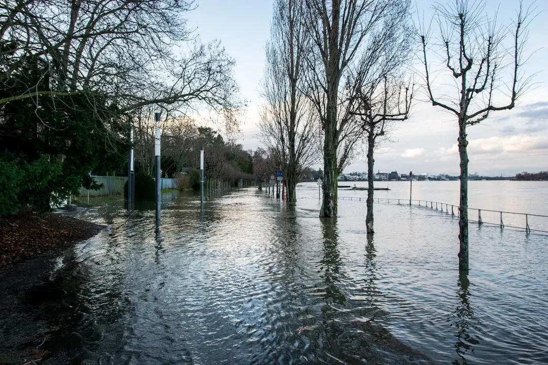
A magnitude 8 or higher earthquake in the area could cause the coastline to slump by up to 6.5 feet. Unlike gradual climate-driven sea level rise, this earthquake-driven sea level rise will happen within minutes, leaving no time for adaptation or mitigation. Imagine waking up one morning and your town is suddenly more than six feet lower than it was the night before. That’s not science fiction.
We’ve seen this happen before. The Tohoku earthquake in Japan resulted in uplift and subsidence of portions of the seafloor in northern Japan and some of the shorelines subsided by 0.6 meters. Scientists say that the subsidence is permanent, and as a result, the communities in question are now more susceptible to flooding during high tides.
The Compounding Threat of Sea Level Rise
It’s hard to say for sure, but the combination of sudden earthquake subsidence and gradual sea level rise might be the most dangerous scenario. A new study published in the Proceedings of the National Academy of Sciences adds an understanding of how much additional land would end up being at a high risk of flooding because of these two combined threats.
In the most extreme scenario, a massive earthquake striking in 2100 would see an estimated 17,710 additional residents, 29,060 structures and 1,000 miles of road affected, representing a 218% increase over today’s exposure, and overall, earthquake-driven subsidence amplified by climate-driven sea-level rise could more than triple flood exposure across the region.
Researchers found that another such earthquake could potentially lower coastlines by more than 6 feet instantly and expand floodplains by as much as 115 square miles. That’s an area roughly twice the size of San Francisco suddenly becoming a floodplain. More than 14,350 more residents, 22,500 additional structures and 775 miles of road would be at risk of flooding compared to current flood risk in the region, representing a 177% jump in residents and a 168% increase in structures.
The study warned that many low-lying areas, particularly in southern Washington, northern Oregon and northern California, may never recover if subsidence is compounded by rising seas, with long-term effects potentially rendering many coastal communities uninhabitable.
Lessons From History: The 1700 Cascadia Earthquake
We actually have some historical evidence about what Cascadia can do. The 1700 Cascadia earthquake had an estimated moment magnitude of 8.7 to 9.2, involved the Juan de Fuca plate from mid-Vancouver Island south along the Pacific Northwest coast as far as northern California, and the plate slipped an average of 20 meters along a fault rupture about 1,000 kilometers long.
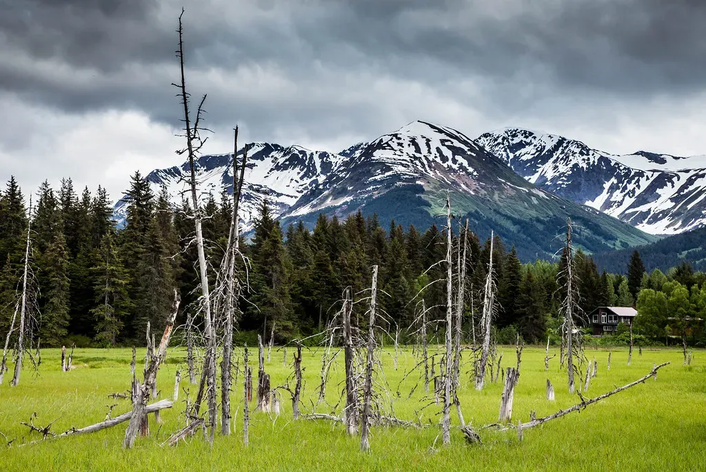
Geologists can still see evidence of the 1700 earthquake causing the coastline to drop between 1.6 and 6.5 feet in the blink of an eye. Rooted organic soils are suddenly overlain by clean tidal mud, indicating they were suddenly dropped down and were buried and basically converted to tidal flats. These ghost forests of drowned trees still stand as eerie reminders of what happened.
The earthquake caused a tsunami which struck the west coast of North America and the coast of Japan. Japanese historical records, which meticulously documented natural disasters, recorded an orphan tsunami that arrived on their shores with no local earthquake to explain it. There is evidence of at least 13 events at intervals from about 300 to 900 years with an average of 570 to 590 years.
So the question isn’t if another massive Cascadia earthquake will happen. It’s when. The clock is ticking, and we’re already more than 300 years past the last one. Let’s be real, that should make anyone living along the Pacific Northwest coast at least a little nervous. What do you think about it? Tell us in the comments.