
In the vast tapestry of natural phenomena that paint the Earth’s geological history, earthquakes stand out as the most dramatic and destructive events. The United States, sprawling across a mosaic of tectonic plates, has witnessed its fair share of seismic upheavals. From the infamous 1906 San Francisco earthquake to the lesser-known but equally devastating quakes in remote areas, these geological events have not only shaped the landscape but also human history and infrastructure within the nation. This article explores some of the most powerful earthquakes that have shaken the U.S., delving into their causes, impacts, and the lessons learned in the aftermath.
The 1906 San Francisco Earthquake
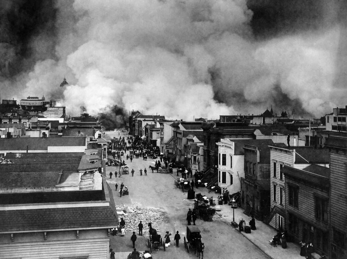
The 1906 San Francisco earthquake is perhaps the most infamous seismic event in U.S. history. Striking on April 18, it reached an estimated magnitude of 7.8. The quake and resulting fires devastated San Francisco, killing thousands and leaving a large portion of the city in ruins. This event marked a turning point in understanding seismic risks and led to significant advancements in earthquake preparedness and building codes.
The 1964 Great Alaska Earthquake
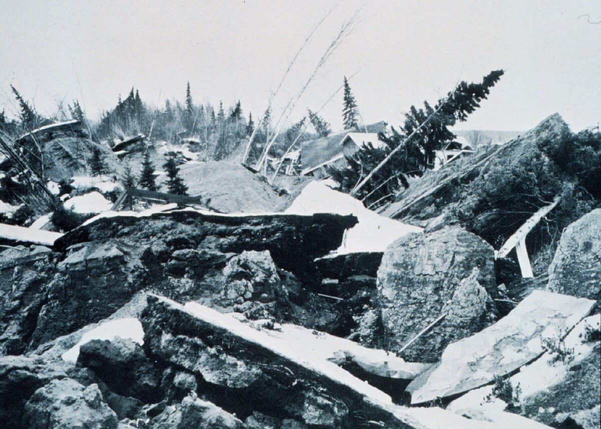
On March 27, 1964, the most powerful earthquake ever recorded in North American history struck the Prince William Sound region of Alaska. With a staggering magnitude of 9.2, it unleashed massive tsunamis and reshaped the coastal landscape. The quake caused numerous fatalities and highlighted the need for improved seismic monitoring and tsunami warning systems.
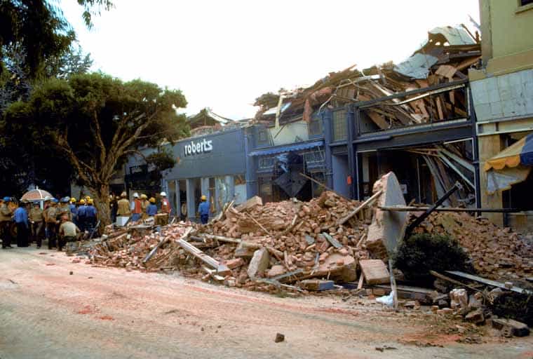
The 1994 Northridge Earthquake

Hitting a densely populated area of Los Angeles, the Northridge earthquake on January 17, 1994, reached a magnitude of 6.7. Despite its relatively moderate size, it inflicted tremendous damage to buildings, freeways, and lifelines, resulting in billions of dollars in losses and scores of deaths. This event spurred advancements in earthquake-resistant design and construction practices.
The 1989 Loma Prieta Earthquake
Striking during the World Series broadcast on October 17, 1989, the Loma Prieta earthquake had a magnitude of 6.9. It caused significant destruction in the San Francisco Bay Area, including the collapse of a section of the Bay Bridge and extensive damage in San Francisco’s Marina District. The disaster prompted further improvements in emergency response and resilience planning.
The 1811–1812 New Madrid Earthquakes
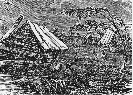
The New Madrid seismic zone, centered in Missouri, was the site of one of the most prolonged and complex earthquake sequences ever recorded in the United States. Occurring in the winter of 1811–1812, these quakes reached magnitudes estimated to be as high as 7.5 to 8.0. They drastically altered the landscape, creating new lakes and diverting rivers. The events startled residents throughout a broad swath of the country, even ringing church bells in Boston.
The 2002 Denali Fault Earthquake
On November 3, 2002, the Denali Fault in Alaska was the epicenter of a magnitude 7.9 earthquake. It was the largest quake to strike the interior of Alaska in over 150 years and served as a critical case study for understanding the mechanics of slip-strike faulting. Remarkably, despite the quake’s power, there was limited structural damage, showcasing the value of remote monitoring and preparedness in sparsely populated areas.
The 2011 Virginia Earthquake
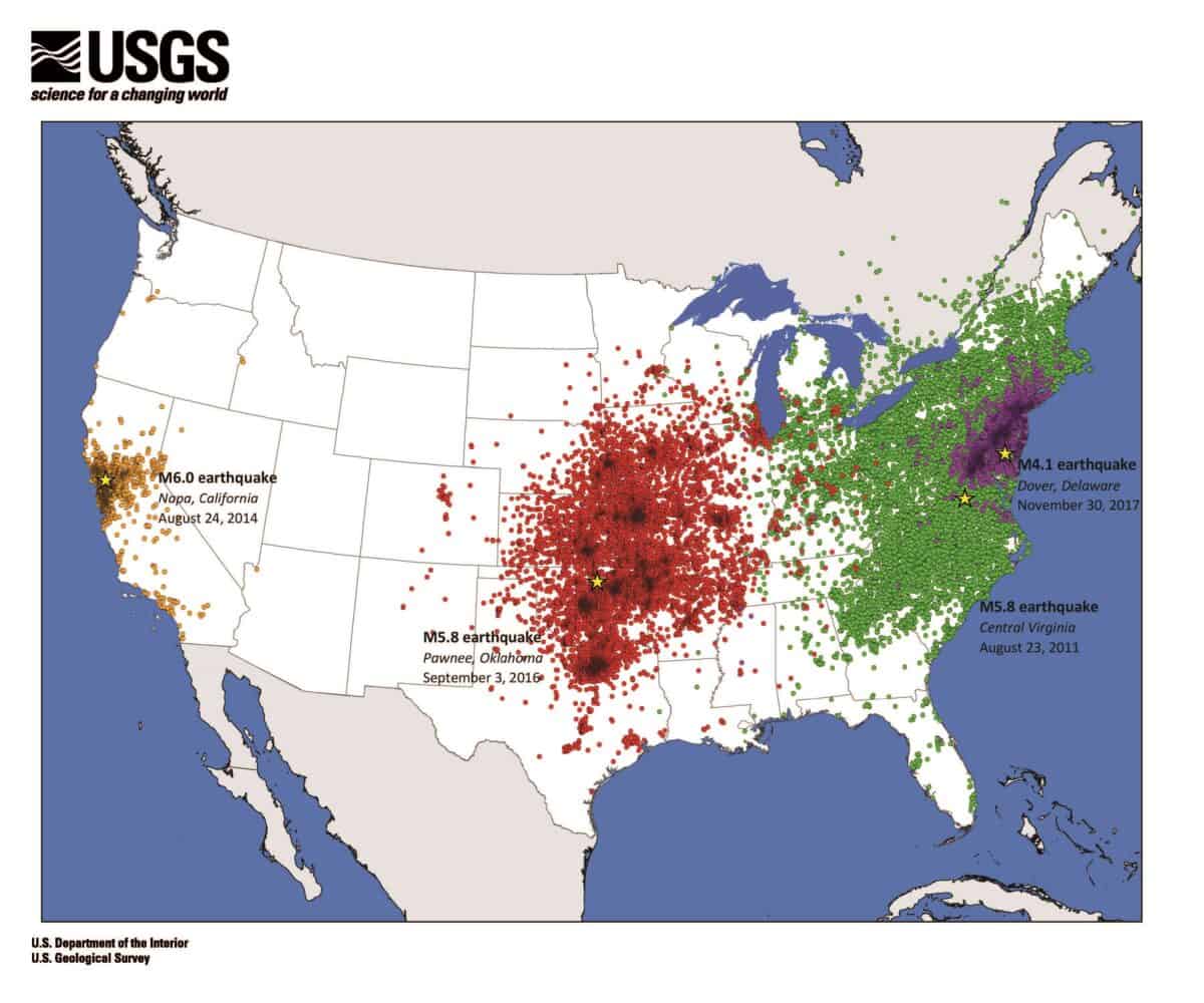
An unexpected magnitude 5.8 earthquake hit Virginia on August 23, 2011, surprising many with its far-reaching impact. Felt from Georgia to Canada, it caused damage to the Washington Monument and the National Cathedral in Washington, D.C. The event underscored the potential for significant seismic activity outside the well-known Pacific Ring of Fire.
The Cascadia Subduction Zone
Though not a single earthquake event, the Cascadia Subduction Zone off the coast of the Pacific Northwest has the potential to unleash a megaquake of magnitude 9.0 or greater. Historical records and geological evidence indicate that such an event last occurred in 1700 and is overdue. This looming threat emphasizes the importance of ongoing research and preparation efforts in the region.
The Charleston Earthquake of 1886
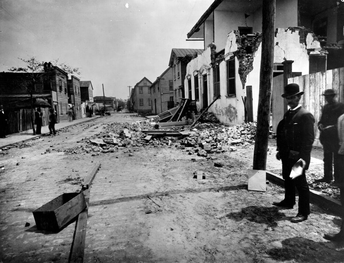
Striking with a magnitude of approximately 7.3, the Charleston earthquake of 1886 is one of the largest seismic events to hit the southeastern United States. It caused widespread devastation across South Carolina, altering the region’s architectural heritage and shaping an early understanding of earthquake risks on the East Coast.
The Role of the San Andreas Fault
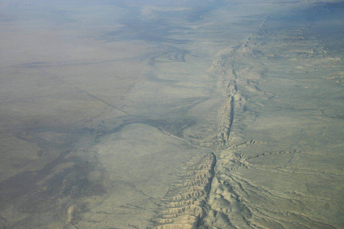
The San Andreas Fault, stretching over 800 miles through California, is the most famous fault line in the United States. It has been responsible for many significant earthquakes in the state’s history, including the 1906 San Francisco quake. Ongoing research and monitoring of the fault line aim to improve predictive models and preparedness strategies for future events.
Advancements in Earthquake Science
Each major earthquake in the United States has contributed to a better understanding of the Earth’s complex geology and has spurred advancements in seismology, engineering, and emergency management. From the development of the Richter scale to the implementation of modern building codes and the establishment of the National Earthquake Information Center, these events have driven progress in mitigating seismic risks.
Lessons from the History

The historical record of powerful earthquakes in the U.S. underscores the ongoing need for vigilance, preparedness, and innovation. By learning from past events and harnessing the power of technology and science, communities across the nation are working to build a more resilient future that can withstand the inevitable shake of the Earth’s next great tremor.
In conclusion, the most powerful earthquakes that have shaken the U.S. serve as stark reminders of our planet’s dynamic nature. They highlight the importance of understanding and preparing for seismic events, not only to safeguard lives and infrastructure but also to preserve the social and economic fabric of communities. As science advances and our resilience strengthens, we continue to stand in awe of the Earth’s immense power while striving to live harmoniously within its ever-changing landscape.
- The Best US National Parks for Spring Wildlife Watching - August 24, 2025
- Why Bears Play—and What It Teaches Us - August 24, 2025
- 12 Dog Breeds That Can Survive a Coyote Attack - August 24, 2025